Route: Mt Gede & Mt Pangrango (Indonesia)

Submitted by ngobrolari on Sat, 10/31/2020 - 10:45pm
Location
Jawa Barat, ID
Distance
24.55 km
Vertical Gain
2,450 m
Description

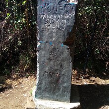
This is the route of the FKT Challenge of Mt Gede and Pangrango 25K. The route starting point is located at the east of Balai TNGP (Taman Nasional Gede Pangrango) Cibodas (1,369m) and follows towards the Cibodas entrance gate. The route then climbs following the stone way path steps that lead to Kandang Badak Base Camp (2,400m). From this point, it leads to the path towards the Pangrango Summit (3,019m), shown by the Tugu Triangulasi, and to the Mandalawangi Memoriam. The path then is a reverse direction and heading towards Mount Gede Summit (2,958m) and the downhill towards Surya Kencana Plateau that stops at the wayfinding signage. From this point is a segment that leads to the finish at the initial starting point (east of Balai TNGP). 

The route will pass by a vast tropical forest that consists not only the stone way path, but also includes steep climbs, a flowing hot water spring, and a spectacular view of the Craters, during the ridge climbing towards Mt. Gede Summit [1].

This route has also been the official route of the Gede Pangrango Speed Trail 2016 race and also the Gede Pangrango 100 yearly event since 2014 [2].  However, some fast times have apparently been set outside of the races.  You should check the race websites BEFORE submitting your FKT!  Please also indicate if your run was set during the race.

Reference:

1. https://www.gedepangrango.org/tentang-tnggp/

2. https://gedepangrango100.com/en


GPS Track

Comments

User Picture
Profile picture for user Irkham Nur Rizki

Keren, semoga bisa seperti beliau² ini. Sangat menginspirasiÂ