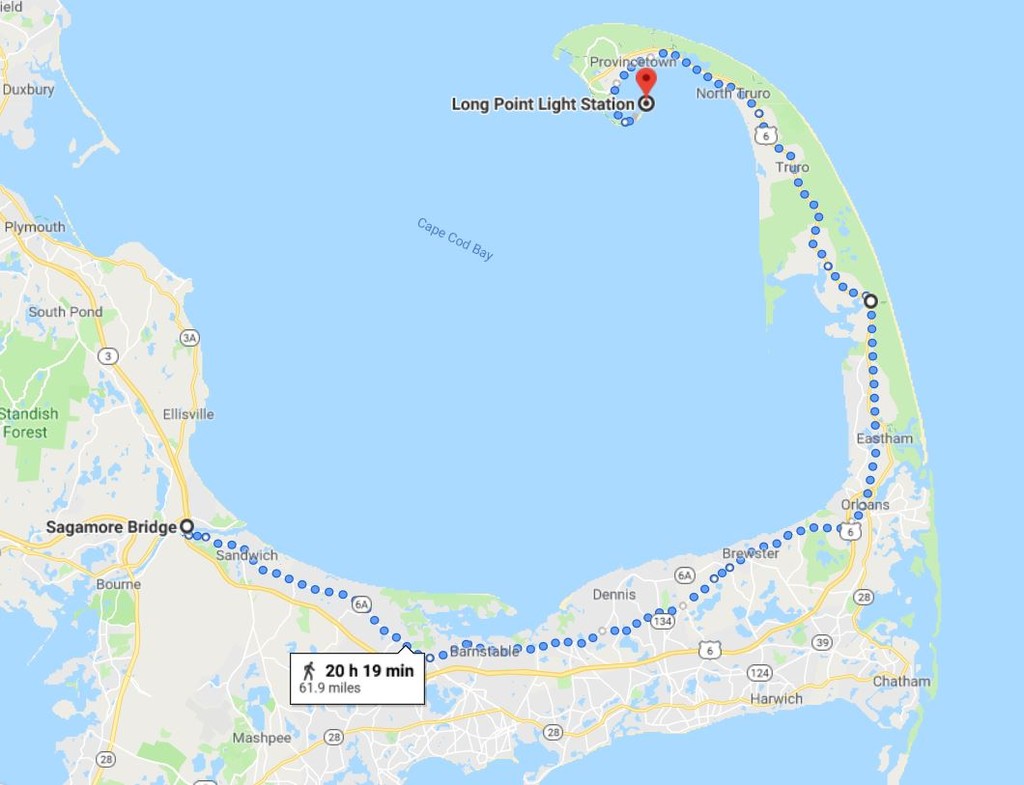
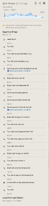
Location
Massachusetts,
US
Distance
64.66 mi
Vertical Gain
1,650 ft
Description
GPS Track
Cap-Cod-Tjersland.gpx4.1 MB
FKTs
Female
Male
| Lila Gaudrault | 8h 59m 57s | ||||
| Rachel Bambrick | 17h 4m 28s |
| Jenny Hoffman | 10h 46m 10s |
| Keith Nadeau | 9h 20m 59s |
Images
Comments
What is the FKT on this route?
13:53:21 Self- Supported, we actually just did it yesterday 5/30/20 . Should be posted soon. You should go for it !!! Great Route for summertime
I will be attempting this route on Friday. Gonna attempt to go unsupported but of course things could change making it a self supported attempt
Did you start on Sandwich Road or on the bridge itself?
I'm hoping to run this route Oct 10 or 17 and while I dont think I'll come close to either of your times, I still want to make sure I run the route in full. Any other tips or thoughts would be greatly appreciated!
Attempting supported on 5/14!
I'm planning to try this self-supported on Mon, June 5, 2023. Two questions:
(1) How long is the time window around low tide to access the Provincetown causeway?
(2) It looks like the posted GPX route crosses the Cape Cod bike trail at Nickerson park, but stays on 6A for another ~1/2 mile to pass through the Shaw's parking lot before actually joining the bike trail. I'm assuming this was just a resupply stop, not a mandatory part of the route, so I could actually hop onto the Cape Cod bike trail at Nickerson park (just to save 1/2 mile on a busy road)?
Self-supported FKT completed on 6/5/2023 in 10:46:10 (pending verification). This is a really fun route! In answer to my own questions, for any future runners:
(1) I had no trouble crossing the rocks & beach about 2 hours after high tide (4 hours before the next low tide).
(2) I did turn onto the Cape Cod Rail Trail (CCRT) where Rt 6A passes over it, at Nickerson Park (just before mile 32). But I had some trouble finding my way off the CCRT back to Rt 6 around mile 46. The paved part of the CCRT ends shortly after Lecount Hollow Rd, and then it becomes mushy sand with some ambiguous "no trespassing" signs. So I recommend turning left on Lecount Hollow Rd to rejoin Rt 6 around mile 44 instead. Rt 6 has a wide shoulder, so it's easy & safe to run on.
I will try a variation of this trail tonight 09/25/2023 running a variation of the posted route. The variation is under Cape Cod Run Against The Tides. I will attempt to break the course record by starting half an hour before the first low tide at 12:01 a.m. My Garmin InReach tracker is share.garmin.com/ratt50.
Alex