The SHT has changed dramatically over the last dozen years.
Below we discuss evolution of the trail and FKTs.
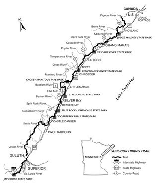
The Superior Hiking Trail runs "310+" miles following the NW shore of Lake Superior in Minnesota. It is a beautiful and rugged, mostly single track trail. The Superior Sawtooth 100 mile race, and a couple of shorter races, use this trail.
SHT reference sheet shows distances along the trail: https://superiorhiking.org/wp-content/uploads/2017/04/2017_SHT_Reference_Sheet.pdf
July 2020 route note: Due to the lack of a bridge on the upstream end of the Split Rock River Loop, the Superior Hiking Trail Association now recognizes a route that employs the Gitchi-Gami State Trail bridge over the Split Rock River near Highway 61 as a part of the official route of the SHT. It is blazed with blue blazes, which indicate the route of the main SHT. This bifurcation/addition to the Trail is due to the lack of a bridge on the upstream end of the Split Rock River loop, which poses a safety hazard to trail users when crossing. In fact, the State Park is discouraging trail users from crossing the river at the old bridge site. The newer route cuts about 2.5 miles off the length of the SHT.
Speed record attempts started on the SHT in about 2005, when the trail was incomplete (about 205 miles at the time). As the trail continued to expand FKTs were set on whatever existed at the time. These trips are documented below. The Superior Trail was completed in 2015(?), and is now "300+" miles long, running from near Duluth to the border with Canada. This article details how the SHT came to be. Though long trails such as the SHT are often subject to reroutes & changes, we consider trips starting in 2016 to be on the more or less "complete" SHT.
Andy Holak attempted an ulta-runner style, supported speed record on the existing Superior Trail in June of 2005. Unfortunately, Andy had to quit after only 40 miles due to an injury. Kurt Decker also made an attempt in 2005, but stopped after 135 miles.
Erik Kaitala was familiar with both previous record attempts. He explains his 2005 speed record of 4d3h43m on the then-completed (205 miles) portion of the SHT as follows:
My attempt in 2005 was based on knowing Andy and Kurt and some issues they had in completing the trail. I want to say that Andy was shooting for 3 days and Kurt had 4 days alloted to finish. In Kurt's case, he had work and other commitments that he needed to get back for and seeing that it wasn't going to happen, he pulled the plug. I was with Kurt when he dropped. Seeing that they did not complete the trail I figured I would give myself 5 full days and that proved to be the difference I think... The SHT runs along the North Shore of Lake Superior and knowing pretty well all of the southern 2/3 of the trail, I decided to start on the southern end thinking it would be easier mentally to finish on sections I had never done. It coincidentally worked out best as the northernmost sections were the least runnable and I wasn't running at all the last 75 miles. My wife, Denise, drove a small RV from trailhead to trailhead and acted as a mobile aid station. Without her, it never would have happened. -- Erik Kaitala, 10 July 2008
Travis Wildeboer, of Winter Park, CO, did the completed 205 miles of the SHT in 4d15h20m unsupported, in May 2009. Wildeboer's splits as follows:
May 9: 41.3 miles. Started at 6 a.m. Finished at Kimball Creek campsite at 7:42 p.m.
May 10: 35.3 miles. Started at 6:04 a.m. Finished at Spruce Creek campsite at 7:58 p.m.
May 11: 44.1 miles. Started at 5:00 a.m. Finished at Crystal Creek campsite at 8:52 p.m.
May 12: 42.0 miles. Started at 4:48 a.m. Finished at East Palisade Creek campsite at 9:25 p.m.
May 13: 47.7 miles. Started at 4:30 a.m. Finished at southern terminus at 9:20 p.m.
Here is Wildeboer's complete report:
I crewed Andrew Thompson on his second Appalachian Trail record attempt and Jonathan Basham on his Colorado Trail record. This is where I became curious to see if I could link together big days. I wasn't prepared to attempt something at the level of these men, but I felt the Superior Hiking Trail would be a good challenge.
I have always wanted to through hike the Superior Hiking Trail but work and time restraints made this difficult. I through hiked the Appalachian Trail in 2000 and reached the summits of all 54 14,000 foot peaks in Colorado in 2001 -- but always with friends. This would be my first attempt at completing something completely self-supported.
During a return trip to my hometown of Cedar Falls, Iowa, I scheduled time to attempt an unsupported record of the Superior Hiking Trail. To my best knowledge, there was no recorded unsupported record of the Superior Hiking Trail, so my plan was to go out and give it all I had.
On May 8, 2009, my friend, Kyle Klingman, drove me to the northern terminus of the Superior Hiking Trail. We arrived at the terminus late at night in the rain and snow so I decided to sleep in the passenger seat of Kyle's Ford Focus. This was not a good idea.
After a restless night of sleep and scrambling to decide what to bring and what not to bring on the hike, I started my record attempt on May 9, 2009 at 6:00 a.m. I started the hike carrying seven days of food with the goal of finishing in six days. The guide book I used was the 2007 edition of the "Ridge Line Press Guide to the Superior Hiking Trail". This guide book has the trail at a total of 210.4 miles. I divided this into six days equaling 35.06 miles per day.
Day One: I hiked the first day through snow flurries and cooler temperatures. I reached the lake walk 35 miles into the hike around 5:30 p.m. and was still feeling okay. I spoke with some college-aged hikers who were hiking north and they said there were some good campsites around the Kadunce River. I decided to keep hiking until 7:42 p.m. where I arrived at Kimball Creek campsite -- 41.3 miles into the trail. It was at this point I decided I could hike the trail in 5 days if I averaged 42.08 per day.
Day Two: I started hiking at 6:04 a.m. with my body feeling good. Sunny skies and warmer temperatures, but the trail was still very wet and muddy. I started to see more blown down trees from a March storm the farther south I hiked. There were piles of wolf scat and deer remains about every mile. I made it 35.3 miles to Spruce Creek campsite at 7:58 p.m.
Day Three: I started the third day at 5:00 a.m. hoping to raise my spirits when I reached the half way point of the trail. I had ran a 50 kilometer race near the Lutsen Ski area so I was looking forward to some familiar trail. I was motivated when I checked the Lake Agnus Trail register and saw there were some through hikers up ahead. Up to this point it was a very lonely hike. The sun came out, not sure of the temp, but it was pretty warm. I had a great view on top of Britton Peak of Lake Superior. I finished day three at Crystal Creek campsite at 8:52 p.m. by covering 44.1 miles.
Day Four: Started day four at 4:48 a.m. just before the rain began to fall. With my right shin beginning to swell and a blown down tree every 20 yards from Crobsy-Manitou State Park to Finland Recreation Area, my pace felt like a crawl. When I arrived at the beaver dam before County Rd 6 I saw some northbound hikers. once again, it was good to see people. After climbing Mount Trudee to the sound of wolves howling, I ended my day at East Palisade Creek campsite, finishing 42 miles at 9:25 p.m. I soaked my feet in the creek and ate the majority of my food. I sent Kyle Klingman a text message asking him to drive up from Minneapolis to the southern terminus. I had 47.7 miles remaining and wanted to finish the following day.
Day Five: I set my alarm for 3 a.m. but slept right through it. Fortunately it started raining at 3:50 a.m. and I was awakened by the rain. When I first put my shoes on and stood up the bottoms of my feet were really sore. Since I knew I wasn't going to need my sleeping pad anymore I used my insole as a template and cut some new insoles out of the pad. This made all the difference in the world and my shoes felt brand new. I started hiking at 4:30 a.m. The sun came out around noon and I saw a few more hikers. By this point my right shin was really swollen and I had developed some "cankles." With 16 miles left at Gooseberry Falls State Park, I had one Clif bar remaining. I only ate half of it, saving other half for Castle Danger. The sun went down as I crossed the Encampment River and I hiked the last miles by headlamp to County Road 301. This is what the guide book called the southern terminus. I finished at 9:20pm. I celebrated the finish with a Gatorade and ride in Kyle's Ford Focus. His seat was more comfortable than I had remembered. I finished my unsupported hike of the Superior Hiking Trail in 4 days 15 hours and 20 minutes. The trail was far tougher than I had imagined. I have a new found respect for Jonathan Basham, Andrew Thompson, David Horton, and other speed hikers who have made similar attempts.
-- Travis Wildeboer, 21 May 2009
Wildeboer also provided his gear and food list for the trip:
| Food | Gear |
| 6 Lipton noodle packs | Lowe Alpine Vision 40 pack |
| 6 ramen noodle packs | pack cover |
| 2 pkg tortillas | Western Mtneering 5 degree bag |
| 1 jar peanut butter | foam sleeping pad |
| 1 block cheese | Petzl head lamp |
| 12 packets oatmeal | Katadyn water filter bottle |
| 10 Clif bars | Ozark Trail rain fly |
| 10 Odwalla bars | cat food can alcohol stove |
| 5 Met-Rx meal bars | Ti pan, plastic spoon |
| knife | |
| tooth brush & paste | |
| Marmont rain jacket | |
| Sierra Designs rain pants | |
| Capilene LS & SS shirts | |
| 2 pr Wigwam socks | |
| Montrail Hardrock shoes | |
| cell phone | |
| guide book |
Alicia Hudelson set the female FKT for the SHT at 4d17h26m (supported), starting at the northern terminus at 5:11 a.m. on May 23, 2009, and finishing at 10:37 p.m. on May 27. Her complete report is on our old website. Hudelson had relatively little ultra experience prior to this trip, having done the Grand Canyon rim-to-rim-to-rim (47 miles), the 55-mile Courmayuer-Champex-Chamonix race, and 70 miles of the Grand Union Canal race.
Cody Bartz completed the 296-mile SHT in 12d4h19m (supported) 7/6/2013:
I completed the new distance, 296 mile Superior Hiking Trail, in 12 days 4 hours and 19 minutes. This took place from June 24 to July 6, 2013. I am not certain, but may be a record for the new trail distance. I started at the southern terminus at Jay Cooke State Park, and finished at the "270 Overlook" into Canada. I had 3 resupplies: Two Harbors, Finland, and Grand Marais. I stayed at a friend's house in Duluth on my 2nd night. She brought me from the trail to her house, and back to the trail in the morning. I hitchhiked into Two Harbors, and amazingly met someone at the post office who maintains the trail. He offered a ride back to the trail. In Finland I walked both ways to get my resupply. I tried to hitchhike, but no luck. And in Grand Marais I hitchhiked into town, stayed at a friend's house that night, got my resupply in the morning and he brought me back to the trail. So I am not sure if this would be considered supported or self supported. I assumed self supported at first, but this is my first time on this site and after doing some reading realized that my hike may be considered supported by some. It was largely self supported with resupplies sent via a bounce box. Here are photos as well as some commentary:
www.facebook.com/media/set/?set=a.10100236310523949.1073741831.33804725&type=1&l=d90af1d59d
 |
 |
Next up was Tim Lupfer & Jared VanderHook doing 296 miles in 8d14h44m (self supported) 5/23-31/2015:
Tim Lupfer and I (Jared VanderHook) completed our self-supported through-hike last night with a total time of 8 days 14 hours 44 minutes setting a new FKT for the 296 mile distance. We used the 7th Edition Guide to the Superior Hiking Trail to plan the trip. We began at the Northernmost point of the trail, the "270 Overlook" and finished at the Jay Cooke State Park Visitor Center.
We had 7 resupply points along the way. 4 resupply caches on the trail using bear bins or hanging dry bags (Grand Marais, Schroeder, Lake County 301 and Martin Road). 2 Post Offices (Finland and Silver Bay). 1 business held our box for us, Eagle Ridge Resort at Lutsen Mountain.
In addition to miles covered on the main trail we hiked into several towns for meals and/or to purchase supplies as needed (Grand Marais, Lutsen, Schroeder, Finland, and Silver Bay). In Silver Bay we hitch-hiked part of the way back to the trailhead. In Lutsen we hitch-hiked to/from the Cascade Restaurant. In all cases we rejoined the trail at the same point we left it.
Here are the daily mile splits:
May 23: 42.5 miles. Started at 6:44am. Finished at Kimball Creek Campsite at 10:30pm.
May 24: 26.25 miles. Started at 6:20am. Finished at Cut Log Camp at 7:30pm. Resupply on trail via hanging dry bag (+3.2 mile round trip into Grand Marais for meal).
May 25: 33.2 miles. Started at 6:30am. Finished at Carlton Peak at 9:15pm. Resupply box held at Eagle Ridge Resort (+1.8 mile round trip into Lutsen Mountain Resort area).
May 26: 27.7 miles. Started at 6:16am. Finished at Crosby Manitou trailhead at 9:05pm. Resupply on spur trail via hanging dry bag (+4 mile round trip into Schroeder for meal).
May 27: 30.8 miles. Started at 5:48am. Finished at Palisade East Camp at 10:45pm. Resupply at Finland Post Office and meal (+3.2 mile round trip into Finland).
May 28: 38.25 miles. Started at 6:10am. *Finished at Gooseberry Falls camp at 11:48pm. Resupply at Silver Bay Post Office and meal (+3.2 mile round trip into Silver Bay).
*NOTE: There was a closed 1.6 mile section of the trail between Blueberry Hill Road and Gooseberry State Park due to a private landowner revoking access. We followed the official detour down Blueberry Hill Road (1.2 miles) and along the Gitchi Gami State Trail parallel to Hwy 61 (2.1 miles) meeting back up with the SHT at Gooseberry State Park near the visitor center. (http://www.twoharborsmn.com/news/3735751-sht-detour-finalized)
May 29: 39.5 miles. Started at 6:08am. Finished at Fox Farm Road Trailhead at 11:13pm. Resupply on trail via stashed bear bins near Lake County 301 trailhead.
May 30: 34.2 miles. Started at 6:16am. Finished at Duluth Lakewalk at 8:20pm (stayed at Fitger's Hotel). Resupply on trail via stashed bear bins near Martin Road trailhead.
May 31: 34.1 miles. Started at 7:40am. Finished at Jay Cooke State Park Visitor Center at 9:28pm.
Also see our SPOT page - sht.moremilesmorefun.com/
And our Facebook page -https://www.facebook.com/jaredtimsht
 |
 |
FKTs
| Cody Lind, Brittany Peterson | 4d 9h 27m 18s |
| Bob Stewart | 5d 12h 1m 56s | ||||
| Alan Chapman | 5d 14h 12m 0s | ||||
| Jeff Rauenhorst | 5d 17h 59m 0s | ||||
| Brian Corgard | 7d 9h 15m 0s | ||||
| Rory Anderson | 7d 13h 25m 0s | ||||
| Ajay Pickett | 7d 20h 56m 0s | ||||
| Mike Ward | 8d 7h 59m 0s |
| Jeremy Platson | 8d 2h 35m 0s |
| Alex Elizabeth | 6d 12h 32m 0s |
Comments
Good luck Righteous!
it was fun watching Brandon these last few days. Did he get hurt?
Sorry I forgot to update on here. I wasn’t prepared for the cold stretch of nights during my attempt. I spent most of the nights shivering and a lot of the daytime weaving around on the trail. I think I’d have been ok if I’d have brought my warmer sleeping bag but I didn’t expect it to get as cold as it did. I’m undecided if I’ll try again in the future. It’s all pretty fresh yet and I can’t say I had fun. If I do decide to try I’ll post again!
I abandoned my attempt on Sunday 9/13 due to foot injury. This trail is a monster and deserves more respect than it gets! Lessons learned, maybe I'll be back for another shot next year.
I will be attempting to break Rory’s unsupported FKT on the SHT starting Saturday 9-5. I will be heading SOBO as well and be tracking with a Coros Vertix and a Spot Tracker.
https://maps.findmespot.com/s/4Y5F/CB
50 miles per day is pretty aggressive for this trail but I am going to try finish under 6 days. Good luck Righteous on your attempt as well!
Get it! I'll be watching closely this week...
I'll be attempting to set a new unsupported FKT going SOBO starting on 9/12. I'll track the attempt with my Garmin watch and Spot tracker as well as pics along the way. https://maps.findmespot.com/s/PQ3L/94
Good luck out there Henry!
You too Brian! Hopefully I'll be tripping over all the roots so you don't have to.
Clear the spider webs for me and I'll be happy.
I will be attempting a supported FKT going SOBO on Oct 1. Follow the Trail Transformation Facebook page for updates.
https://maps.findmespot.com/s/HPPV
Yeehaw!
Bailed out at 250. Pretty significant water retention caused all kinds of problems. I will be back.
Day 1-https://www.strava.com/activities/4214090270
Day 2-https://www.strava.com/activities/4214090406
Day 3-https://www.strava.com/activities/4214090339
Day 4-https://www.strava.com/activities/4214090254
I’m attempting an unsupported FKT starting this morning. Oops!
https://share.garmin.com/jeffr
Great work out there Jeff! You earned it! I'm lucky I was three days ahead of you and not behind because you've set an incredible bar- congrats!
-Madeline Gould : )
I will be attempted a male supported FKT on the trail heading Southbound starting May 27.
Track progress during the attempt: https://share.garmin.com/flynnsquad
Updates on the attempt and during! https://www.instagram.com/flynn_squad/
Share the fundraiser with others: https://venturemiles.org/myVM/SHT
https://www.strava.com/athletes/45309526 (Name: David Flynn)
Dropped at mile 200 at W. Castle Danger Rd.
Hi all. I'll be attempting a SOBO unsupported FKT starting July 30 because hot, dry and smoky just seems so appealing!
Live tracking: https://share.garmin.com/troywanless
Tapped out on day 2 at the Cascade River / Co Rd 45 trailhead. Despite my efforts to drink plenty of water and stay loaded I became way too dehydrated and my body just wasn't able to keep up. Huge props to all who have finished or even attempted this route. The SHT is one beautiful and gnarly trail.
Going to give the unsupported SHT a go from south to north. Put very little prep into this and don’t even know how I would get from the north terminus back to Duluth but that’s half the fun. Starting tomorrow morning at some point. First FKT tracking with a Somewear device: https://somewear.co/public/tracking/1e041149-71c4-44ce-9b83-9890a2e650b2
i think it will work, but il also upload daily to Strava. This will be interesting.
Good luck Jeff!
I'm making a SOBO attempt at the women's unsupported FKT of the Superior Hiking Trail. Starting this Friday, September 30th. I'll be tracking with my GPS watch and will upload links to my gpx files on Strava when I'm able to do so. I have a Zoleo satellite phone that will be privately tracking my location for my family but it doesn't have an option to share a link publicly. Strava should work fine though :)
Was on track to set the new record but my headlamp broke. Will have to come back and try again :)
This sounds awesome! Has anyone tried this as an out and back?
Attempting a Self-supported FKT starting today around noon!! Tracking with my Garmin watch and an Inreach Mini!
You can follow along with the attempt here:
https://www.strava.com/athletes/johnnysolberg
https://share.garmin.com/johnnysolberg
Hoping to finish in 7 days!
Hello friends!
I’m very excited to announce that I will begin an unsupported FKT attempt, heading southbound, on Monday, August 14th.
You can begin following me at approximately 6 a.m. on 8/14 here: share.garmin.com/5RZ2W. I will attempt to upload my watch data to Strava (https://www.strava.com/athletes/56272960) at the end of each day, but cell service is not the best and I will be trying to conserve phone battery.
The SHT is my favorite trail in the world, and I can’t wait to spend the better part of a week immersed in it. The trail offers a wonderful combination of beauty and brutality - featuring breathtaking views, captivating plant and animal life, significant elevation changes, and enough roots and rocks to destroy even the toughest of feet. This unique place exists because of the time, money, and sweat invested by thousands of people who have come before me.
With this all in mind, I’ve teamed up with the Superior Hiking Trail Association (a nonprofit organization devoted to trail construction, maintenance, management, and promotion), who are running a summer member drive from August 11-19th. Their goal is 500 members. I just renewed my membership and invite you to join me and a growing community of SHT supporters! You can do this here: https://superiorhiking.org/join/
Happy trails!
Good luck Alan!
SHTA is a fantastic organization that everyone that hikes the SHT should support.
I am going to attempt a new women’s supported FKT SOBO with a planned start on 8/30. I’ll be tracking through strava with updates to Instagram (@leah_kunkel)