http://www.borderroutetrail.org/
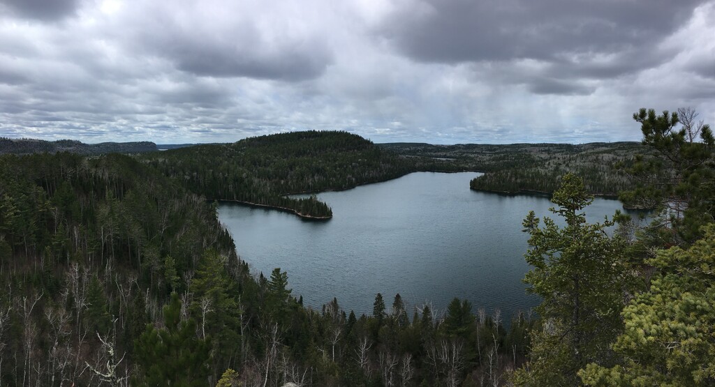
The Border Route Trail is a 65-mile long hiking trail that crosses the Boundary Waters Canoe Area Wilderness (BWCAW) in the far northeast corner of Minnesota (Arrowhead) and follows the international border between Minnesota and Ontario, Canada. It connects with the Superior Hiking Trail on its eastern terminus and with the Kekekabic Trail on its western end at the Gunflint Trail (Cook Cty. Road 12). The closest towns are Grand Marais (beginning of Gunflint Trail, County Rd 12) and Hovland (beginning of Arrowhead Trail, County Road 16). In addition to the eastern and western termini, the Border Route Trail can be accessed through several spur and connecting trails, allowing for hiking trips ranging from short day-hikes to multiday backpacking expeditions. On these pages, you will find information for planning your hiking trip on the Border Route Trail: BWCA regulations, outfitters, trail heads and announcements of upcoming trail clearing events on the Border Route Trail.
The trail was planned and built in the early 1970's by the Minnesota Rovers Outing Club with the help of the Minnesota Department of Natural Resources and the US Forest Service. It was the first long-distance, wilderness backpacking and hiking trail in Minnesota planned and constructed by volunteers. The Border Route Trail Association was incorporated in 2004 to coordinate the maintenance and increase public awareness of the trail. The trail continues to exist by the efforts of volunteers and our valued partner relationships.
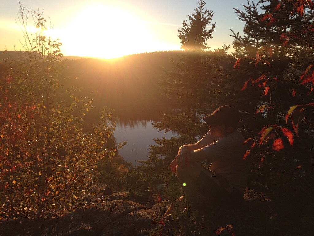
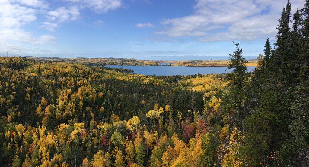
Loop (run-bike duathlon submitted by Matthew Matta): This variation on the Border Route Trail started out of necessity. I wanted to try an FKT on the BRT but it is extremely remote, so finding someone to help shuttle cars around is difficult. Hitching is problematic. It would likely require 4 or more hitches to make it from end to end, if you can even find someone for the remote eastern trailhead. If you take the main roads along Lake Superior and down to Grand Marais it’s more than 80 miles of driving. There is a person who runs a shuttle in the summer/fall but not in the spring, which I believe is the best time to try for an FKT. With a mountain bike however you can cut through on forest roads and logging trails and get the mileage down to around 50. I eventually decided that this would be my best option. This would make a multi-sport loop of around 68 miles of running and 4-5 hours of biking, under ideal circumstances. The Border Route Trail itself is one of the more scenic trails in Minnesota. Much of it is on ridge lines between large lakes that are oriented east to west. The bike section adds some winding gravel forest roads and about 25 miles of the Gunflint Trail, a historic route used by native Americans, miners, and fur traders. This main access route for the Boundary Waters is now paved and is very popular with tourists in the fall when the leaves change color. The section between the Gunflint Trail and the eastern trailhead has a few different options, including Greenwood Lake Rd and Shoe Lake Rd, but there are also many smaller forest roads and trails that are fair game and may shave off a few miles. This was a fun challenge both physically and logistically and the scenery is some of the best in Minnesota.
https://www.borderroutetrail.org/
https://www.trailrunproject.com/trail/7024055/border-route-trail
Randy Niemiec posted about the route and his FKT attempts in 2012 & 2013 on our old website:
Niemiec, 7/26/2012:
This Sunday, July 29, I plan to establish a fastest known time for the Border Route Trail in Minnesota.
An Internet search using the words "fastest known time border route trail" yielded an attempt by Stephen Regeneld to complete the trail in less than 24 hours. He gave no specific time for how long it took him to complete the trail, but, by his account (http://gearjunkie.com/border-route-trail-minnesota-trip-report), it was more than 24 hours. My Internet search did not yield any other attempts at a fastest known time on the Border Route Trail. I hope to complete the trail in less than 21 hours.
The Border Route Trail Association defines the western terminus of the trail as the Gunflint Trail and the eastern terminus as the Superior Hiking Trail (http://www.borderroutetrail.org/trail.html). I will be using this definition for my trip.
I will be traversing the approximately 65 mile trail from west to east.
My record will be for a trip that is supported from the Gunflint Trail to the last road crossing before entering the Boundary Waters Canoe Area Wilderness (BWCAW), N. Loon Lake Road, and from the first road crossing after exiting the BWCAW, the Arrowhead Trail, to the Superior Hiking Trail and unsupported between N. Loon Lake Road and the Arrowhead Trail, including all parts in the BWCAW. Thus, I will be supported during the westernmost 13 miles and easternmost 12 miles and unsupported for the middle 40 miles, approximately.
Please feel free to meet me on the trail. I plan to start at approximately 12 a.m. on Sunday morning on the Gunflint Trail (County Road 12). I estimate I will cross S. Gunflint Lake Road between 2 and 3 a.m. I plan to cross N. Loon Lake Road around 4 or 5 a.m. I hope to arrive at the Arrowhead Trail (County Road 74) between 3 and 6 p.m. and finish my trip at the Superior Hiking Trail somewhere between 6 and 9 p.m.
Niemiec, 7/31/2012:
I gave it a try, but wasn’t close to being up to the challenge.
I started out with Scott Bordon at the western terminus of the Border Route Trail shortly after midnight. Scott accompanied me over the first 12 miles all the way to N. Loon Lake Road, where we met my wife and children. We walked all those 12 miles, as I thought it best to conserve energy for running until daylight when I would be able to get more bang for my buck. I had been hoping to arrive at N. Loon Lake Road between 4 and 5 a.m., but didn’t make it there until 5:45 a.m.
Between the western terminus and Gunflint Narrows Road, we lost the trail momentarily from time to time, but were able to find it again without too much trouble. East of Gunflint Narrows Road, though, we came across lots of additional trails and there were often no markings to indicate which trail was the BRT. On three occasions, we spent a significant amount of time on the wrong trail and lost a total of at least 40 minutes.
We also had significant issues with thick undergrowth. At times it was up to our chests. The undergrowth made it hard to do a fast walk and obscured rock and fallen logs and other hazards, which led to falls and near misses. It was all fair, but made progress slow.
In terms of logistics, I had planned to be finished by dusk later that day and had made that same commitment to my wife. While I hadn’t even started running yet, I knew much of the trail ahead was not runnable for me, I would be entering a long unsupported section, plus fatigue would come eventually. After doing 12 miles in 5.75 hours, it didn’t seem realistic to do the last 53 in the remaining 15 hours of daylight. I was feeling fine physically, but decided to call it quits.
The fact that I would have no access to my crew for the next 40 miles definitely played a part in my decision. If I could have done another 10 miles, for example, to see if I could get back on pace, I would have, but it was all or nothing for that 40 mile section.
Congratulations to Stephen Regeneld for completing the whole trail. It’s a beastly, rugged trail.
Thanks to Scott Bordon, my wife Meg Hoyt, and my children Isabel and Winnie for their support.
Niemiec, 6/19/2013:
I’m going to make another go at it. Details remain largely the same as from my epic fail last summer. This Saturday, June 22 is the date and I’ll be going from west to east once again. Here are a couple of key elements for my attempt:
>Old school navigation only; I will be using only a compass and map to navigate.
>Unsupported on the approximately 40-mile road-less section from N. Loon Lake Road to the Arrowhead Trail.
Feel free to meet me on the trail. I plan to start at approximately 12 a.m. on Saturday morning on the Gunflint Trail (County Road 12). Road crossings and estimated arrival times are as follows: S. Gunflint Lake Road, between 2 and 3 a.m.; N. Loon Lake Road, between 4 and 5 a.m.; Arrowhead Trail (County Road 74), between 3 and 6 p.m.; Superior Hiking Trail (eastern terminus) between 6 and 9 p.m.
-Randy Niemiec
Niemiec, 6/25/2013:
The short story is I had a much more respectable showing than last year (52 miles completed), but the end result was still the same (didn’t cover the full 65 miles).
I started out from the western terminus at midnight with Sean Faulk. We ran some, but mostly walked because of roots, rocks, and undergrowth. Like last year, after crossing Cross River on North Gunflint Lake Road, we had difficulty figuring out which way to go when we came to intersections, but had much less difficulty than last year (arriving at North Loon Lake Road at 4 a.m. this year vs. 5:45 a.m. last year). We were able to average 3 miles per hour on this twelve-mile section, as I had hoped, without exerting ourselves too much.
My wife Meg was waiting for us at North Loon Lake Road. Meg and Sean helped me resupply with fluids and food before I headed out on the forty-mile road-less middle section unsupported.
I had hoped to continue my 3 miles per hour pace on this section, but was unable. The terrain was extremely technical, with lots of roots and rocks. On top of that, it was often impossible to see the roots and rocks because they were obscured by undergrowth. In the end, I did very little running on this section and was able to only cover 2.5 miles in a good hour. I lost about 30 minutes when I took a wrong turn shortly after Bridal Veil Falls. I made another wrong turn just a few miles before reaching the Arrowhead Trail. I ran into a group of Boy Scouts portaging from Daniels Lake to Rose Lake but didn’t see anyone else the whole 40 miles. I reached the Arrowhead Trail at 8:20 p.m., much later than the 6 p.m. I had hoped for.
This was as far as I made it. Earlier in the morning it had rained for an hour or two. In my desire to travel light, I had worn only a t-shirt and shorts and didn’t carry any extra clothing. I had thought about bringing a garbage bag to use as a poncho or a reflective blanket, but decided against it. The temperature was around 60F, but nevertheless I got very cold. After the rain stopped, my clothes eventually dried out and I was able to get warmed back up. The sky remained overcast the rest of the day. The weather greatly reduced the risk of dehydration, but ended up being my undoing.
About 6 p.m. it started to rain again. Even though I was walking fast, I was shivering. I felt like I was in danger of becoming hypothermic and didn’t think I had the mental wherewithal to navigate the BRT in the dark for a second night in a row, so even before I finished the forty-mile middle segment I decided not to do the last thirteen-mile segment.
When I got to the parking lot at the beginning of the last segment at 8:20 p.m., Meg and Sean were not there. The rain was still coming down steadily, I had no other clothes, no rain gear, and I was almost out of food and fluids. I was very worried about hypothermia. After unsuccessfully trying the doors of the vehicles in the parking lot, I crawled into a boat that had a cover on it. Shortly thereafter Meg and Sean arrived. They had been tracking my progress using the messages sent from my beacon, but because I picked up my pace the last few hours, I arrived earlier than they thought I would.
My difficulties with getting cold at the end highlight an interesting dynamic. I wanted to travel light but that forty-mile road-less section can be very dangerous if something goes wrong.
Thanks to Meg for allowing me to give this a try again. I know it scares the crap out of her when I'm out in the middle of nowhere alone like that. Thanks to Meg and my daughters Isabel and Winnie for putting up with all the time I spent training. Thanks to Isabel for the Shwings she gave me to put on my shoes. They helped me go faster on some very difficult terrain! Thanks to Sean for accompanying me on those first 12 miles, reassuring Meg while I was doing the middle section, giving me advice, and going on training runs with me no matter how early, how far, and how cold it was. Thanks to Sean’s daughter Abby for making the trip and helping keep my daughters company so Meg and Sean could concentrate on supporting me. And thanks to Sean’s wife Becky for letting me borrow Sean and Abby for the weekend.
-Randy Niemiec
Ed Solstad 7/8/2013:
You're getting closer - another try and you might just complete it in 24 hours. You should find the McFarland to Swamp River section to be relatively easy to follow, certainly better than the Ham Lake Fire burn areas around Gunflint Lake. Best of Luck!!
Randy Niemiec 7/23/2013:
Ed, thanks for the encouragement. I like to think of you as the father of the Border Route Trail. For those of you who don’t know, Ed played a huge role in designing and creating the trail in the 1970s and continues to coordinate maintenance of the trail. Without Ed Solstad, there would be no Border Route Trail. Ed, I would love to join you for one of those maintenance trips later this summer or fall to give a little back to a trail that has given me a lot.
Eric, good to hear from you. I would definitely be up for a 24 hour run next year.
-Randy Niemiec
Ed Solstad 12/5/2013:
Randy, If you give it another try in 2014. I'd suggest going in mid to late May before the thimbleberries, etc. get a chance to obscure the trail. Hopefully there will be an earlier spring next year and we'll be able to get some meaningful maintenance done early on.
Best,
Ed


Comments
This coming Sunday, May 27, I will be attempting to establish an FKT on the Border Route Trail, traveling west to east. I plan to start a little later than prior trips, knowing that the western portion can be difficult to navigate so I want to do that after it gets light. I will have both a beacon and a GPS watch, but will be navigating using map and compass.
Unlike the prior attempts, I will receive aid at one point during the 42 mile wilderness portion (approximately halfway through). I should have 17 hour of light to work with, and it doesn't look like the underbrush is as bad as it has been for people later in the year.
I will post here again afterwards.
How did you attempt go runningfalcon?
I went through halfway (the Clearwater Lake campsite) in 9hr53minutes before I pulled out. I had set a cutoff of about 9 1/2 hours for that point (based both on my own comfort and my crew's).
I had three navigation errors (two that were less than a quarter mile, ~5 minutes, and one that was more like a mile plus) that probably tanked my effort.
I'm plotting a return next spring, but no firm plans as of yet.
Tomorrow, Thursday September 6, 2018 I intend to set an FKT on the Border Route Trail (BRT). I will start at the eastern terminus around 3:00 am and run West. I plan on meeting my friend Nick at the Daniels Lake Access Trail intersection around noon and then running the remaining 30 miles together. This will technically make my run supported, though I will accept no physical aid from him.
I plan on reaching the Western terminus of the BRT at Gunflint Trail before 11:00 pm, for a total time of sub-20hrs. I could not find anyone who has completed it in less than 24hrs. I’ve seen the reports from a few who have attempted it but had route finding or weather issues. From what I’ve heard this year the trail sounds more clear and easier to find than usual. Two years ago I hiked the eastern 35 miles to the Daniels Lake Access Trail with Nick. We have been looking for a good work/weather window to finish the trail and the forecast is beautiful for tomorrow. This will be our first time on the western 30 miles.
Saturday, Oct 6th, 2018, I intend to establish an FKT on the Border Route Trail (BRT). I will be starting Sat. morning and traveling west to east. I will be unsupported.
I am aware of another attempt starting on the same day, and he will be traveling east to west (we are exchanging the car key in the middle). I hope to set the west to east FKT and also establish the female FKT.
Here is a link to my SPOT tracker. It will be active when I begin.
http://share.findmespot.com/shared/faces/viewspots.jsp?glId=0h5G3WYr3sfacpghadglGlM8ecxsadqOL
For weather, it looks like the trail may receive a little snow on Friday, but I am hoping rain later in the day will melt whatever snow falls. The trail will be muddy, but that's the way it is. Other trail conditions are unknown at this time. On Wed. night a storm with high winds came through northern MN and I am hoping not many trees blew down across the trail.
I will be attempting an east to west FKT on the Border Route Trail, starting the morning of Saturday October 6th 2018. I will be starting at Otter Lake Road, and finishing at the Magnetic Rock Trailhead. I will be unsupported on this effort, with a key pickup near the middle from the female FKT attempt that is occurring the same day.
I will have my friends Garmin InReach along with me, tracking the progress at the link below:
https://share.garmin.com/Runions
Start time should be around 6:30 AM CDT, 6 October, and finishing sometime early Sunday morning, 7 October 2018.
Update: Looks like jeffo finished the route this morning in around 25h50m, east-to-west, and Faye Norby finished in about 28.5h, west-to-east. The two crossed late last evening somewhere near Rose Lake. Good job you two!
Carter Stritch and I will be starting an FT attempt on the BRT the morning of October 20th.
That's a lot of darkness to run through. How'd it go?
I completed the trail in 23:31:53. http://www.movescount.com/moves/move249993751#table-year=2019
Hi all,
I'm announcing my intent to run a FKT on the Border Route Trail in one week, June 29th. I'm doing this in an effort to bring awareness of the threat of sulfide-ore copper mining to the trail running community. I'm working with the Campaign to Save the Boundary Waters, Patagonia, the BRT Association and others to highlight this run and the threat BW faces.
I'm running this as Phase 1 of an overall program of "Running Across the Boundary Waters." This October, Phase 2 will be the Kekekabic Trail and next year, date TBD, I will run both in one continuous route - which I don't believe anyone has attempted, or at least documented. Along the way I also intend on running other established trails in the BWCAW - Pow Wow Trail, Eagle Mtn, Souix-Huster Trail, etc. Just for fun, but also in a continuous drip drip to keep highlighting the issue to fellow trail runners.
I honestly have no idea how long this run will take me, I've researched quite a bit, read others (Jeff's in particular from this site as I'll also be running East to West) trail reports, etc. But part of true Wilderness running is the complete unknown - how many trees will be down and over the trail, how thick will the brush/scrub be, what's the weather gong to be, etc. These challenges are also part of the thrill of running such a route.
I'll be doing this run unsupported, carrying what I need with me. Thankfully water in the BW is so clean I'll be refilling along the way (which is why we're trying to keep this place free from mining pollution!).
I chose this time of year to maximize my daylight times as the 29th was as close to the summer solstice as I was able to fit in my schedule. I'll be setting out around 4 am - just pre-dawn to cover the first 12 miles of more maintained route from the Otter Lake trail head to MacFarland lake where I'll enter the Wilderness and ever increasingly remote aspect of the run.
I have a Garmin inreach I'll be carrying with that will send out a beacon every 10 miles and I'll put up a link to that route before I head on my way. Please follow along, I have a website for this project at: https://www.runningforthebwca.com where you can also sign my petition and/or make a donation to Save the Boundary Waters.
Wish me luck and happy trails!
Good Luck! I will be keeping a eye on your progress. Let me know if you need any more intel.
Thanks Jeff, just saw this now as I was putting up my Garmin tracker link. ummmmm, think it's just any last minute thoughts you have about the trail. I've been on sections of it on the western side and some in the middle on canoe trips at the stair way portage for a couple mile hikes on either side. but the rest of the trail is relatively unknown. I'm thinking I'll be likely to be headed out the western side and I'm actually most worried about getting lost with all the resort paths out there vs. interior of the wilderness. hopefully running at this time of year will help with maximum sunlight available to me.
anywhere in the middle of the wilderness part you remember that was particularly challenging or something I should be aware of?
I'm mostly just excited for the adventure and to be able to cover this much ground in the BW!!
Hi all,
here's the link for my Garmin tracker! the route should be on there as a red line from Jeff's gpx file. my inreach will drop a beacon every 10 minutes so will leave a decent track behind me.
wish me luck!
https://us0-share.inreach.garmin.com/RunforBW
I realized just now I never updated my run here. I did not finish the entire route - a confluence of events of breaking a toe at mile 17 and91 degree with 70% humidity gave me heat stress. I started East headed west and made it 56 miles to Loon Lk Road on the other side of the Wilderness and had to call it quits unfortunately. I have a full run report on my website. I'm still committed to coming back next year for the full attempt at the BRT and the Kek. Next week, Oct 12th I'm running the Kek! I'll post over there shortly.
My BRT attempt run report
I will be attempting a supported FKT on the Border Route Trail beginning at midnight Friday, October 18 heading West to East. I will be accompanied by a friend for the first 12 miles and the last 12 miles of the trail, but will be solo through the BWCA section.
-Bryan
I completed the BRT on Saturday night, October 19, 2019 in 21 hours, 56 minutes, 43 seconds which is a new supported FKT. Here is a link to the Garmin Connect tracking. One note on the time - I accidentally hit the pause recording button on the watch, but realized immediately and resumed recording. The time you see on the Garmin Connect is ~20 seconds slower than the time I am reporting. I looked at the starting and ending time stamp of the raw .gpx file to calculate the actual time. I am happy to share the .gpx file upon request.
My friend Ben ran the Magnetic Rock Trailhead to Loon Lake Road section and the McFarland Trailhead to Swamp River Trailhead section with me. I resupplied with food and water at Loon Lake Road and the McFarland Trailhead.
I'll post a trip report soon.
-Bryan
I just submitted a new unsupported FKT on this run. As the thread above, the trail got the best of me last year, but I came back with a vengeance this time around with a successful complete and a new unsupported FKT. serious props to Jeff and Faye on their first runs on this trail and their route descriptions that helped my planning.
I'll gladly buy a beer for the next FKTer here!!
Gretchen Metsa and I will be attempting the unsupported mixed-team FKT on the BRT going east-west on 6/18/21.
*Correction - West to East.
What a wild adventure!
Not as many water stops as we thought so we both got pretty dehydrated.
Plenty of highs and lows but we pulled each other through.
The trail made the SHT look like a cakewalk. Rugged, overgrown, and plenty of options for wrong turns.
No moose sightings :( But plenty of tracks!
Final Time: 17:23:08
https://www.strava.com/activities/5500125075
Hey all you cool cats and kittens. I’ll be attempting the BRT from east to west tomorrow 9/24.
What an adventure! I have been planning this attempt since last fall and could not have experienced a more rewarding endeavor.
The day began on the eastern terminus off of otter lake rd. My Mom (Karen) and Uncle (Gregg) cheered me on as I departed the trailhead a few minutes after 6AM on Friday, September 24th. After a mile or two on the combined SHT/BRT I took a sharp left and headed on long journey to the west trailhead some 65 miles away. The first section was relatively smooth, except for a 1 mile detour around mile 7/8. Upon realizing my mistake I headed back up the spur trail to the Border Route trail. This detour added an additional two miles to the route.
The 1st aid station was McFarland lake where I picked up my only pacer for the day, Dave Hackworthy. Dave accompanied me on the longest section of the day without aid (22.8 miles). We traveled well and started hitting some steep climbs pretty soon after our departure form McFarland Lake. The wind picked up and rain started falling. Around mile 25-30 I started experiencing the biggest mental low of the entire day. The gravity of the miles ahead started setting in and the fear of running the next 35 miles alone creeped up. I had two falls during this section, down some slippery rock faces descending two different palisades. Eventually with Dave's encouragement I came around mentally and was moving well throughout the section. As I neared the Daniels Lake Spur Trail/BRT intersection my enthusiasm started to build!
The 2nd aid station was located at the Daniels Lake Spur Trail/BRT intersection (mile 35.6 I think). My buddies John and Kevin hiked the 3 mile spur trail to bring in aid. This was huge, really built some momentum here. I ate some food, drank some caffeine, shared some war stories, dropped off Dave, and went over time windows for the rest of the day. At this point I realized that the FKT was attainable if my body held up over the next 30 miles. After changing into dry clothes, shoes, and socks I took off on the next 11 mile section to meet John/Kevin at the Mayhew Lake spur trail intersection.
What a beautiful section, it started with some very runnable terrain around the lake shore, then headed up rose lake in to some old growth forests. At this point I felt mentally and physically strong, the name of the game was keep pushing without getting lost. I filled up at several streams and moved swiftly throughout this section. I rolled into the 3rd aid station at the Mayhew Lake Spur Trail/BRT Intersection (45 miles I think). This aid station was more of a nascar pitstop. Quick refresh on water/snacks, picked up a headlamp, and I was off. The next aid station would be the loon lake road crossing 10 miles ahead, where I would take more rest before the final push.
During this section of 9-10 miles I moved well, feeling the end in sight (kind off!). About 5 miles in I had to turn on my headlamp and push through endless fields of overgrown alders and ferns that cover the trail. Legs are pretty scratched up post run.
I came into my final aid station at loon lake road with close to 3 hours and 45 minutes to achieve the overall fkt. I ate some hot quesadillas (so good), put on some warm clothes and gloves, drank a red bull, then set off to finish the mission.
The final 10 miles were by far the hardest to navigate....especially in the dark. Every half mile to mile I questioned where I was and had to often run with my map out to ensure I was not lost. What was even crazier was the massive rock slabs that were hundreds of yards in distance, these rock slabs did not make finding the trails in the dark on the other side very easy......it was so challenging. Through it all we persevered and I finished the Border Route Trail on Friday night in a final time of 16 hours, 51 minutes, and 36 seconds.
I owe so much to the volunteers who maintain this rugged and remote trail. Thanks to my crew, Mom/Uncle/Kevin/Dave/John. And to my wife who supported me through all the training over the last year.
To the Border Route Trail, you have a piece of my heart forever. Thank you for being the toughest trail I've ever encountered, you allowed me to push beyond my perceived limits and for that I am forever grateful.
Is there any difference in difficulty traveling East to West or West to East? Or is it a horse a piece?
Sorry I didn't see this before. E to W is easier in my opinion, although navigation on the W end can be tricky after 50 miles. The W half has more bailout/resupply options, and there is talk of building an AT&T tower near the W terminus.
I will be attempting the Unsupported FKT of the Border Route Trail, tomorrow morning, October 9th, 2022. Starting out at the Western Terminus, Magnetic Rock Trailhead, and will head eastbound to the Eastern Terminus, Otter Lake Road Trailhead. No idea as to what time I will finish in, or if I will, but an attempt at the Unsupported FKT is the goal.
Attempt unsuccessful. Will go for it another time.