Jimmy McCaffrey initially posted the route. Over time the route evolved, and also there were some differences in exact routes taken by different people. In late 2020 there was a discussion and agreement among previous FKT holders to determine the exact FKT route. The route description below, and corrected GPX track, was provided by Chris Thoburn (Chris thanks Jennifer Walker for carefully proofing the new description, as well as to Kristina Randrup and Katy Pieri-McCaffrey for giving it a read for clarity. A broader thank you to the former/current record holders Paddy, Brian, Lucy, Tara, Marcy, Katy, and Allen as well as to Jared Forman for their feedback on the route both on the board and in person.)
.
Strava Route: https://www.strava.com/routes/2728002236206310200
Official Site: https://www.ebparks.org/parks/trails/east_bay_skyline_national_trail/default.htm
About
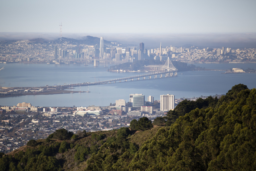
The East Bay Skyline National Recreation Trail is a continuous point-to-point traverse following the ridge line of the coastal mountains along the Hayward Fault. The trail is a mixture of fireroad and single track with a few paved trail miles on Nimitz Way. This route rewards with stunning panoramic city, bay, and valley views, groves of Coast Redwood and Eucalyptus, as well as canopies of Fern, Moss, Coastal Live Oak, and Bay Leaf.
First built and designated as part of the historic 1968 National Trails System Act, the East Bay Skyline National Recreation Trail today shares many of its miles with the Bay Area Ridge Trail and the Juan Bautista de Anza National Historic Trail. The trail is well marked with shields and sign posts emblazoned with the classic "USA" National Recreational Trail logo. The portions overlapping the Bay Area Ridge Trail and De Anza Trail are similarly marked with their logos.
From North to South, the route links together eight distinctive parks with minimal low traffic road crossings: Wildcat Canyon Regional Park, Tilden Regional Park, The Siesta Valley Recreation Area, Sibley Volcanic Regional Preserve, Huckleberry Botanic Regional Preserve, Reinhardt Redwood Regional Park, Anthony Chabot Regional Park, and Lake Chabot Regional Park.
The Route
The FKT Route follows the East Bay Skyline National Trail precisely with only two exceptions: an addition at the northern terminus, and the use of French Trail through Reinhardt Redwood Regional Park instead of staying on West Ridge Trail.
Detailed Description (North to South)
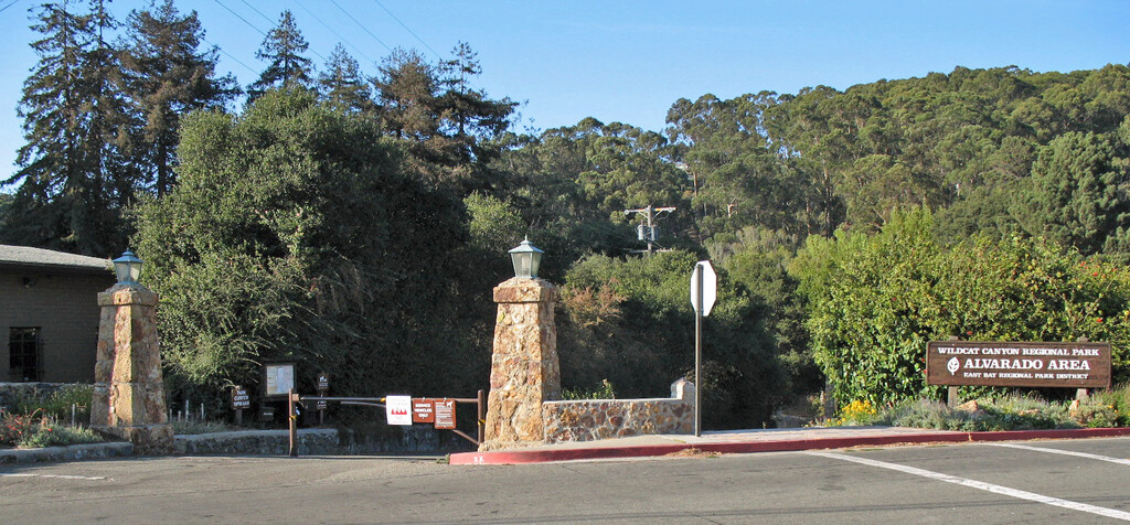
From the stone pillars at the entrance to Alvarado Park, head into the park.
Alvarado Gate to Top of First Climbs (2.86mi, +1145ft/-264ft)
After ~400ft, just over the bridge and before the buildings on the right, turn right onto the soft gravel path. Keep on this for ~0.25mi and you will exit into the Wildcat Staging parking lot. The signpost at this junction is the start of what is officially the Skyline National Recreational Trail; here you will see your first marker of the day for the route with an arrow indicating to head left through the parking lot. (Water, Restrooms, Parking)
At the end of the parking lot (~0.25mi) stay straight to pass through the trailhead gate onto Wildcat Creek Trail. Continue another quarter mile and make a left onto Belgum Trail.
At 1 mile, after a long climb and then a short descent, turn right and take the steep climb to begin on San Pablo Ridge Trail.
Continue on San Pablo Ridge Trail for 1 mile to reach the highest point of the Wildcat portion of the trail. Ahead of you will be a wooden corral where the trail links up with another fire road before continuing straight to the left of the corral.
Top of First Climbs to Inspiration Point (4.52mi +393ft/-411ft)
Continue on San Pablo Ridge Trail past the corral for half a mile. There, it transitions into the paved Nimitz Way. Continue on the paved Nimitz Way trail to Inspiration Point (Restrooms, Parking).
Inspiration Point to Lomas Cantadas Road (2.98mi +964ft/-357ft)
At the end of the paved Nimitz Way Trail, just before the gate with the large stone pillars, turn sharp right to descend onto Curran Trail. Follow Curran Trail for ~.15mi until you reach a four-way junction with a small singletrack that heads up and to the left. Take the singletrack, and after a few hundred feet, cross the road and continue onto Seaview Trail.
Continue on Seaview Trail for ~2.15mi until you reach Arroyo Trail.
Make a right onto Arroyo. After ~0.12mi, make a left onto Lupine Trail (signs for the ridge trail). Go ~200ft then stay straight/right onto Vollmer Peak Trail. After a quarter mile, exit the trail into the parking lot.
Run through the parking lot (Restrooms, Parking) alongside the access road, staying straight past "Steam Trains" (Water, Restrooms, Parking) (The Redwood Valley Tilden Steam Train) before crossing Lomas Cantadas Road. On the far side of the road you will find a trail with stairs to a gate. Pass through the gate onto the Skyline Trail.
Lomas Cantadas Road to Sibley Staging Area (3.3 mi +582ft/-833ft)
This section of the trail is on the EBMUD managed Siesta Valley Recreation Area. While most EBMUD usage requires a permit, use of the East Bay Skyline National Trail does not. Other trails (including side trails) in this park do require a permit.
Proceed ~0.28mi until the single track intersects a wider trail. Turn right and uphill to stay on Skyline Trail. Proceed an additional ~0.12mi and pass through another gate. Continue straight to stay on Skyline Trail.
After ~1.02mi of downhill single track, you will cross Fish Ranch Road. This is the busiest intersection you will cross with the highest potential for speeding cars with more limited sight lines. Continue ~1.05mi further to intersect Old Tunnel Road. (Parking) This is a low-traffic low-speed parking area. Off the trail about 150ft around the bend on Quarry Road are some additional parking spaces with a permanently maintained port-a-potty (Restrooms, Parking).
Cross Old Tunnel Road and pass through the gate to continue on Skyline Trail. The trail will begin fairly flat but after a short climb and descent will climb for about a half mile until you reach Sibley Staging Area (Water, Restrooms, Parking) for a total from Old Tunnel of ~0.84mi.
Near the top of the climb, the trail makes a sharp left up towards the paved trail just in front of the restrooms. Make a left onto the pavement and then an immediate right to continue ascending on the trail.
Sibley Staging Area to Skyline Gate (2.9mi +666ft/-848ft)
Continue on Skyline Trail for ~0.2mi until it exits into an extra wide intersection. Stay straight, slightly to the right, and uphill. After crossing the paved access road you'll find another signpost to continue onto SkylineTrail / Round Top Loop Trail.
Continue ~0.13mi and cross another paved access road. After crossing and continuing on the trail, keep right to stay on Skyline Trail. Descend for ~0.76mi to reach the junction with Lower Pinehurst Trail. Turn right and ascend ~0.12mi. Turn sharp left onto Lower Huckleberry Loop / Skyline Trail.
Continue on Lower Huckleberry Loop / Skyline Trail for ~0.54mi to where it meets the stair connector to the Upper Huckleberry Loop Trail. Note: Some FKT attempts have taken this connector and utilized the upper trail, adding a bit of distance and vert and a tougher trail by doing so. However, the official FKT route and the official Skyline National Trail route both continue straight here on the lower trail. If you are using a GPX track for navigation, you may want to ensure in advance that it utilizes the lower trail.
Continue on Lower Huckleberry Loop / Skyline Trail for ~0.36mi and then stay straight onto Skyline Trail. After ~0.17mi cross Pinehurst Rd and ascend onto the Bay Area Ridge Trail. Continue for ~0.26mi and turn right when the trail ends onto East Ridge Trail. Continue ~0.18mi to Skyline Gate Staging Area. (Water, Restrooms, Parking).
Skyline Gate Staging is roughly the mid-point for this route.
Skyline Gate to MacDonald Staging (5.9mi +1038ft/-1706ft)
Note: Cell service and GPS accuracy from the beginning of French Trail through MacDonald Staging is highly unreliable.
From Skyline Gate, continue onto West Ridge Trail for ~0.51mi. Turn left to descend onto French Trail for ~0.6mi. French Trail temporarily joins Tres Sendas Trail. Continue straight to stay on French Trail for ~0.08mi and then turn left to cross the stream to keep on French Trail.
After ~0.45mi, at the top of a climb, stay straight to keep on French Trail. Descend for ~0.12mi to reach Starflower Trail. Turn right as French Trail momentarily joins Starflower Trail, and almost immediately turn left to ascend again on French Trail.
After ~0.11mi, keep left at the top of the climb to continue on French Trail (Madrone climbs to the right).
After ~0.53mi, keep straight to continue on French Trail (Mill Trail joins from the left).
After ~0.43mi, keep straight to continue on French Trail (Fern Trail crosses).
After ~0.34mi, keep left to stay on French Trail (Chown Trail continues straight and up to the right). After a few hundred feet stay straight to continue on French Trail (Chown Trail joins from the left).
Continue on French Trail for ~0.9mi until it joins Orchard Trail. Turn right onto Orchard Trail and ascend ~0.18mi. Turn left onto West Ridge Trail.
Continue on West Ridge Trail for ~0.55mi. During a steep descent, just after a set of sharp turns, find the Golden Spike Connector Trail on the right. While this is the official trail, this connector is not well marked and one of the most easily missed junctions on the route.
Take the connector, and after a few feet when it joins Golden Spike go right. Continue ~0.63mi to reach a junction with an unnamed connector. Note, as of 1/26/2021 the signpost here for the Skyline National Trail is broken off and laying on the ground. Turn left and descend ~0.1mi on the connector to Redwood Rd.
Cross Redwood Road and head left through Big Bear Staging parking lot (Parking) to the trailhead at the South East corner. Continue straight on this trail paralleling the road for ~0.1mi until it reaches MacDonald Staging Area (Parking). Continue straight to cross the parking lot to the MacDonald Trail trailhead in the South East corner.
MacDonald Staging To Bort Meadow Staging Area (2.6mi +509ft/-637ft)
Ascend MacDonald Trail for ~1.1mi until you reach a 3-way junction just after it flattens out. Turn left to continue on MacDonald Trail. (Parking To the right ~0.1mi away is the MacDonald Trailhead on Parkridge).
Continue on MacDonald Trail for ~1.45mi. Shortly before reaching the parking lot (Parking), exit the fire road by making a sharp-right and descending the single track. Take your first turn, a sharp left. Continue straight to cross the access roads and reach the gate to Grass Valley Trail.
Note: There is water and restrooms ~0.22mi up the access road in the opposite direction at Bort Meadows Campground.
Bort Meadow Staging Area to Marciel Road (4.6mi +687ft/-463ft)
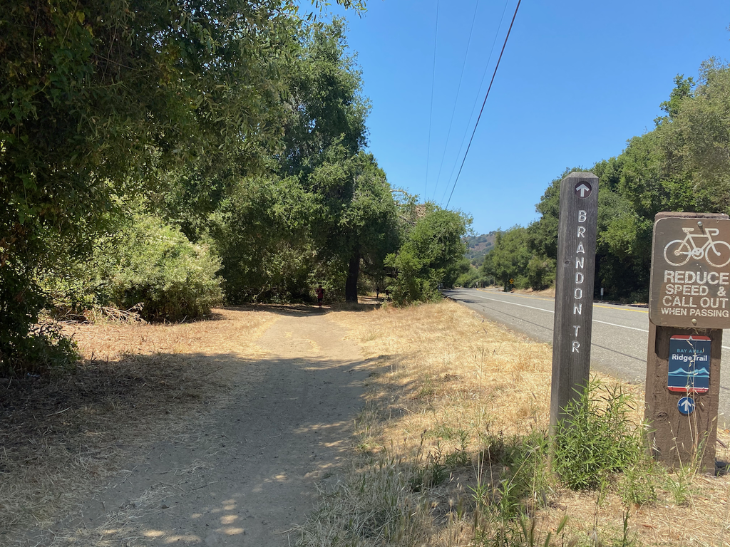
Head through the gate onto Grass Valley Trail. After ~1.5mi turn left onto Brandon Trail. You will keep on Brandon Trail until Proctor Staging.
After ~2.45mi, just pastyour second encounter with Loggers Trail, there is a water spigot at the bend on the right. (water).
Continue ~0.65mi to reach Marciel Road (Restroom, Parking)
Marciel Road to Proctor Staging (2.0mi +32ft/-589ft)
Cross the road and pass through the gate to continue on Brandon Trail. After descending ~1.55mi to the golf course, continue straight southbound along the single-track between the parking area and the golf course fence.
Near the entrance to the golf course, cross the road to continue on Brandon Trail / Proctor Trail. Continue straight on the trail, paralleling the road until you reach the sign post just before the paved entrance to Proctor Staging. FIN
Style Note: Generally accepted practice would be to use public spigots for water under "Unsupported". If you purchase snacks or drinks that's "Self supported".
Photo of the gate at Alvarado Park from Wikipedia, subject to CC By-SA 3.0
.JPG)
Comments
Well, looks like I get the first comment for this route on the new site...!
Hi! My name is Tara Madsen-Steigmeyer, and I'm planning to follow in Marcy's footsteps and try to improve on her EBST time from last year. I know I won't be able to do justice to her photo documentation, but I hope to shave at least a bit of time off. This is my first ever FKT attempt, so I'll see how it goes. I've run the middle section of this route a handful of times (and some sections LOTS), but this will be the first time I've run through Chabot. I'm looking forward to doing the whole thing! Thanks to Jimmy for getting it started, and to Marcy for setting a women's benchmark.
My plan is to make an attempt on Thursday, Jan 31st. I think my husband will drop me off at the start before kindergarten drop-off, so I expect to start around 7:30a. I'll post my Strava track and pictures when I'm done!
I've been thinking since last spring about doing an out-and-back on this route, so I'm planning to try it tomorrow (Feb 18). Starting/finishing at the south end. Self-supported, carrying everything from the start except water (refills at fountains). Should be interesting!
InReach will be running: https://share.garmin.com/MarcyBeard
It looks like most (maybe all) of the self-supported times here should actually be considered unsupported.
Ay-oh! What a lovely route I must say.
I have been doing most sections in separate occasions and I plan on doing the full route tomorrow morning at sunrise to avoid the weekend and day crowds in this special period of social distancing.
Due to water fountains being unavailable at this time, my partner will likely meet me at Skyline Gate for a quick 1L refill for the last 13 miles. I understand this will count as "Supported" effort.
I'll try to get as close to 4:18 as I can but more realistically, my legs are probably just good for a 4:45+ range.
I'll share the good stuff tomorrow when done.
Hi again! What a fun morning it was with a 5:01:01. I got dropped off and picked up by my partner Kristine. And I ended up doing the route unsupported carrying all needed stuff.
Here is the trace with the full report: https://www.strava.com/activities/3239780079/overview
And I share the report here for those who don't use Strava:
Has anyone run this route from South to North? And does anyone know whether any of the water fountains are currently operational? I'm planning to give it a go later this week but can carry at most 3.5 liters (and tend to drink a lot, especially when it's hot). My hope is that the South-to-North route will give me the psychological boost of feeling like I'm running "home," since I've been living near Tilden and running the northern segments pretty regularly.
Hi @eriehl, water was wrapped in plastic at Sibley Staging Area and at Skyline Gate last weekend (5/16/20). However, a trail runner reported the plastic was removed the day after.
Hi all! I'm planning an attempt on this FKT tomorrow. I'll be running supported since most of the water sources in the hills are turned off right now. I honestly have no idea what time I'm aiming for - perhaps 5:30 is reasonable? It will be toasty but I hope to start early enough to beat the heat. Looking forward to the adventure!
Hi my name is Sarah Klass and I'll be attempting this FKT on Thursday July 9th. The plan is to run it with my friend Alex (for his birthday!!) Starting around 5 am. The plan is to fill our water at the steam train site if the water is flowing, but everything else will be individually carried. So I believe this will count as unsupported. Aiming for 5:30 ish. Weather looks pretty nice and hopefully it's not so crowded.
I'll be running with Sarah. I don't think we'll be anywhere close to the men's FKT, but thought I'd post here for posterity. Also, there seem to be different starting locations in a few of the FKTs... We are going to start from the Alvarado Staging Area because this is where all of the original runs started (e.g., Jimmy, Allen, and Marcy). This starting location makes the route just over 50 km. Here's the map of our planned route: "https://www.alltrails.com/explore/map/map-da4fb5c--14". Should be fun!
Just a heads up for anyone exploring here and looking for a good map, the route Alex posted here on all trails has a decent number of deviations from the standard course. While a lot of small variations have occurred over the years, the route that is typically competed hasn't changed from the route initially established (and which follows the official trail throughout). I've created a Strava Route for folks wishing for a clear map: https://www.strava.com/routes/2728002236206310200
Hi my name is Chris Thoburn.
I'll be attempting to set a new record on this course tomorrow morning. The plan is to start around 6am from Alvarado gate to beat the heat and tackle the traditional "uphill" (North to South) route. https://www.strava.com/routes/2728002236206310200. I might start a bit late given I'm not much of a morning person ?. I ran this route just a minute or so slower than the current male self-supported/unsupported FKT a few months ago when I was just barely recovered from lung surgery. For this attempt I'm hoping to dip under 4 hours.
I'll be leaving car at the finish, getting a ride to the start, and carrying everything with me (likely 1.5-2L). Water is still off at all spigots directly on the course other than at Steam Trains. This will be a fully unsupported attempt (no fountain usage, no pacing).
If all goes well I'll report back!
I missed the sub-4 but did lower the record to 4:12:46 https://www.strava.com/activities/3903756002
I've submitted this as "unsupported" since I carried everything. In the past, attempts which relied only on the on-route water fountains were marked self-supported (even though within rules these were unsupported attempts), I think folks should likely continue to make this distinction for the route: use-of-fountains = self-support, no-use unsupported.
Hi everyone,
After Katy's time was flagged, Peter Bakwin and I had a short back and forth about it on her report (see https://fastestknowntime.com/fkt/katy-pieri-mccaffrey-east-bay-skyline-…). In particular, I felt that it was potentially unfair to flag Katy's time for the variation she took by accident when connecting to Golden Spike (which made the course longer and harder). Specifically, unfair because every single FKT submission for this route has by some definition taken a variation, including (as I will describe below and which came as a surprise to me given the effort I underwent to verify the route in advance) my own.
I think it is important for the future of this FKT route that we work together to clarify the exact route being undertaken, even if it means flagging some (or potentially all) of the existing FKTs. In the spirit of transparency, I'm posting here my analysis of all of the existing FKTs. Please know that I think everyone here has done an amazing job running this route, that all of these efforts are fantastic, and the goal here is not to discredit any of these efforts but to solidify the route so that we can have a clear and consistent standard for evaluating submissions going forward.
The need for this clarity is evident in many of the comments below and in the reports themselves, folks often describe variations they have taken or noticed because of confusion for what exactly the route here is, so I hope given so many have noted this issue, that folks will be generally receptive to an outcome here that works to eliminate such confusion. I further see evidence of this confusion on Strava, where many attempts that I've reviewed there have contained the variations seen here (and many more!). Perhaps the best evidence of confusion is that Brian's later (just barely unsuccessful) attempt at retaking the FKT from Paddy (done with Kris Brown and Paul Balmer) had multiple variations from his own previous route. My own first attempt (also a near miss at Paddy's record) also had a variation (Bort Meadows Parking).
What is the route?
In order to describe variations on the route we must first have a route to work from. For this, I will be using the route defined by the downloadable GPX file / browsable map here on the FKT site. HOWEVER this route is not actually the route described in the FKT description, nor the route used by the FKT establisher. It is instead the route used by Brian Gillis when he set his record. This is likely one of the largest reasons this route has become confusing. My own attempt followed this route precisely, but since it is not actually the original route I think its only fair to say that all of FKTs listed here have a chance of being flagged.
Variation Definitions (with descriptions of their dis/advantage)
Variations in One Way Attempts
As a reminder, these are variations against the GPS track currently listed as the official one for the route, which is not actually the original route described and established. This is why even Jimmy McCaffrey's time below has variations listed.
Variations in Out-And-Back Attempts
Proctor Staging End Point Variation
It has never been specified exactly where this FKT starts/ends at Proctor. Some GPS tracks indicate heading into the parking lot, some photos use the sign board in the parking lot, and some (including mine) end at the signpost marking the start/end of the skyline trail. Every attempt's GPS track seems a little different here but GPS reception in that narrow valley under the trees can also be misleading.
Conclusions
If we look at the route as originally laid out by McCaffrey against the GPS track from Brian's FKT there are only two differences, where the northern terminus is, and whether you take the lower vs the upper trail in Huckleberry. Factoring in that the southern terminus in Proctor has never been clearly defined that gives us three things to consider. Lastly, we should consider whether the tiny variation at Bort Meadows Parking should be a "runners choice" or if a specific route should be enforced. I think all of the other variations here are for clear reasons (at least to me but I'm happy to spell it out if needed) not variations that should become part of the route (even though I happen to like the single track over the humps shortening the connection between Belgum and San Pablo).
So to summarize, I think there are four key things for us to clarify.
Happy Trails!
- Chris Thoburn (runspired)
Wow this is terrific work! Thanks for taking the time. This seems to have become a pretty competitive FKT, so it would be great to really nail down the exact route. What is the correct route? Is it the GPX we have, the described route, or something else? Can this be determined by carefully following signs on the ground? It would be great if we had a GPX that matches the route description!
My Recommendation
My recommendation is that the course should start at Alvarado Gate, then follow the Skyline Trail precisely (which means taking the lower trail through huckleberry), divert from Skyline Trail only to take French Trail, allow either option of connecting at Bort Meadows, and finish at the signpost where the trail meets the road at Proctor Staging.
If folks are in agreement, I can produce a GPX track for it (either via exporting one I create manually or by actually going and running this again, which would be fun). Additionally I think we should rewrite the description of this FKT both to ensure the description is clear and accurate but also because the existing mileages and elevation were poorly measured even for the course they describe (off by nearly 2 miles). I am happy to take this on.
My research and reasoning for this is below.
Route Research
I don't think anyone here would disagree that the spirit of this route is "The entirety of the East Bay Skyline National Trail but with taking French Trail through Redwood Regional Park". Most of this course is extremely well marked by a recognizable "USA" style Skyline Trail logo.
With that in mind I thought I'd do some more research to try to answer these questions. The online resources for this trail are scarce, and don't clarify the start nor the choices at Huckleberry / Bort Meadows. https://www.ebparks.org/parks/trails/east_bay_skyline_national_trail/de…
The best we can get from the online map and description is that the start is definitely not Wildcat Gate but closer to Wildcat Entrance. The best we can get from the online description for Huckleberry is that horses and dogs are only allowed on skyline trail through the park, which would rule out the upper trail which is definitely not horse friendly.
What also have a few other key pieces of info to figure this out:
With this in mind I went to see what trail maps for Bay Area Ridge Trail had to say, since more maps and online resources typically exist for it
Unfortunately it was still vague around the intersection of Bort Meadows, and joins the trail up on the ridge in Wildcat (vs starting with it) so that was as good as any online answers were going to get.
With these questions and this info yesterday evening I went out to the trail and re-reviewed and photographed the signage at all three locations taking in mind both northbound and southbound travel. Here's what I came away with.
Lower vs Upper Trail in Huckleberry
The lower trail in huckleberry is clearly marked as the Skyline National Trail.
Where this can be confusing is the first sign you see heading southbound before the connector when coming up from San Leandro creek could be read as "take the connector to skyline trail", however both the sign and signpost at the connector are clear that the lower trail is the skyline trail. This is reaffirmed by the signage at the southern end where the upper and lower trails come back together, by the signage at the top of the connector, and by the sign post with the map at the entrance to huckleberry park (which is not on the route, but a good resource).
Bort Meadows
Few markings exist, the only noticeable one would be seen by northbound travelers only and is unclear.
There is no signage on the trail when heading southbound to let you know to veer right onto what we've been calling the connector. The only sign in the parking lot is at the north end and simply lets you know that you're getting onto the Skyline Trail (the "connector" is only a few feet beyond it). There is no signage at all on the southern end of the parking lot.
On the "connector" trail itself there are signposts clearly indicating that the connector is not actually a connector but rather the intersection of Macdonald Trail and Grass Valley Trail, which is the two trails you are supposed to connect for this route. These signposts do not have any of the three possible regional trail markers.
Exiting the "connector" trail we find a sign post indicating for both the DeAnza and the Bay Area Ridge Trail to take the connector.
A little further, at the foot of the paved road down from the parking lot, is a large sign post that seems to indicate taking the paved route up to reach Macdonald Trail with the Skyline Trail logo on it. However the positioning of this post is awkward in part due to the complex nature of this intersection (3 way split paved/gravel road crossing with an additional trail junction and fire road junction).
My recommendation here is that variation at this junction should be "whatever the runner does", the total distance covered here is maybe .15 miles via either way of connecting, and neither way seems noticeably longer or more challenging.
Start Location
The indication from online resources that the start is not at Wildcat Gate but closer to Wildcat entrance is confirmed by the signpost where the road at the entrance meets the trail being taken by those starting at Alvarado Gate. On this signpost is a clear Skyline Trail marker and arrow, I searched diligently throughout the rest of Alvarado Park for any other sign posts with Skyline Trail markings, there are none.
You will only see this marking if traveling southbound. As a side note, other markings do exist in Alvarado Park for the DeAnza trail plotting a course through it that while not exactly the course being run from Alvarado Gate is fairly similar and even a bit more straightforward.
This signpost is an odd place to start and end this route, you won't see the marker if traveling northbound and you will still be searching for it to figure out where to start if traveling southbound. For this reason I think the clearest start/end is Alvarado Gate and that we should officially set that to be the terminus, any effort arriving at it would have had to pass this signpost thereby having completed the full official trail, it is a clear physical marker with good permanence, and it is distinctive in photos.
End Location
Running through the parking lot to the sign board at Proctor feels funny to me. I think we should clarify the end should be the extra large Bay Area Ridge Trail / Skyline Trail signpost next to the Brandon trail signpost right where the trail dumps onto the road into the parking lot. It's a nice clear thing to touch at the end and know that you are finished, and should be decently resistant to change or permanent loss as a physical marker.
I found this online map of the De Anza trail, showing how it routes through Alvarado Park and Bort Meadows. https://nps.maps.arcgis.com/apps/webappviewer/index.html?id=9f862c19b33… Interestingly at Bort the connection goes through the parking lot BUT the connection is also labeled as unofficial. Basically the trail has a gap and there's an unofficial way to connect via the parking lot.
Chris, first off - great job on your FKT on this route, that is a stout time! Secondly, I think it is commendable that you are trying to develop a consensus for an "Official" route for FKT purposes. As you very clearly and painstakingly laid out, the route has been done with many variations by many people since Jimmy's initial FKT standard was posted. Most of this is due to confusing and/or inadequate signage I think. I'm pretty sure that Jimmy and I did the exact same route, however things started to get confusing after Brian Gillis' FKT as he used some variations (including a different starting point I think) that were "standard" to him as he had apparently been running some version of this route periodically over the years as a fun run of sorts. So after Brian's FKT there were 2 different versions of the course out there in addition to all the places where signage is confusing or inadequate, etc.
While I used to live very close to northern terminus of this trail in Wildcat park, I have since moved to New Mexico so I can't go out and check the signage. Jimmy and I both started at the Wildcat gate and to me that has always seemed like the logical place to start - it's where the parking lot ends and there is an actual gate there. But I never took the trail that you took from Alvarado gate and in fact I had no idea that was possible, and I don't remember the signpost you mentioned near the Alvarado gate.
I agree that the lower trail in Huckleberry seems right but I don't remember the signage there exactly. I do know that I've run the entire skyline trail at least 5 or 6 times and I've likely run the huckleberry section more like 20-30 times and I always tried to follow the signage so I assume that means the lower trail is "correct".
Regarding the Bort meadows section, I don't really remember much about that, except that it was confusing. It seems like it doesn't really make a difference so i'd agree with your evaluation there.
Regarding the southern terminus, I don't remember the sign you are talking about but if it is where the trail comes out of the parking lot makes sense to me.
I'll be heading out tomorrow morning for a go at this route. Going unsupported and live in Richmond so will be starting at the southern terminus @ Proctor and finishing at Wildcat. Looking forward to it and will let you all know how it goes.
Hi my name is Jared Forman and tomorrow morning I plan to challenge the unsupported male FKT record on the traditional N->S one way route. I will carry all water/gels and run solo. I plan to depart at first light around 6am.
Based on Chris's research and recommendations, I will be starting at Alvarado Gate and taking the Lower Trail in Huckleberry. If air quality is bad in the morning, I will postpone this attempt.
I will report back if all goes well!
I had a great day on the trail on Friday, but came up short after taking a wrong turn at mile 27 (right instead of left onto Brandon) and added an extra 3.7mi and 30mins looping back to Bort Meadows. I got it right the second time around and finished in 4:46.
It was a little smoky at the start, but conditions were perfect (high 50s and foggy) and I felt ready, so I went for it. Although I was starting to feel tired of this trail after running on it a number of times on the couple months leading up to this attempt, I had a newfound appreciation for its beauty seeing it in the morning fog with the sun rising. I don't plan on racing this again anytime soon, but you never know.
For those considering this unsupported, I carried 2.5L of water (consumed ~2.1L) and consumed ~1500cals.
Thank you Chris for trying to sort through this. I'm open to whatever official route gets decided on, and I agree with Chris's recommendations. It would be super helpful to have a final decision on these questions for future attempts.
1) My response to the comments made about the variations for our runs:
I can resend my one-way InReach tracking files to Peter for reposting, if that would be helpful. It's still the low-res InReach tracker with less frequent points.
a) I have always used the Alvarado gate (big sign labeled "Alvarado Staging Area") on the north end of the route, for the one-way start and the out-and-back turn-around. This decision was most likely made to match the first FKT tracks. I see where my out-and-back track didn't go far enough (my "OK" check-in on the InReach wasn't at the gate like it should have been); however, see photo:
https://fastestknowntime.com/fkt/marcy-beard-east-bay-skyline-national-…
b) I have never taken the singletrack in the field from Belgum up to San Pablo Ridge; always the fire roads (the steep down and back up). All the points on my InReach tracks are on the correct route, so I'm not sure where that "variation" in the out-and-back came from (a misunderstanding in my trip report?).
c) Regarding the Huckleberry upper/lower trails, whatever signage or research you found that shows one to be preferable to the other, that makes sense to me. I believe I've been on both of them at one time or another, but I expect I always took the Lower trail during my FKT runs to match Jimmy's route (just don't have the tracks to prove it).
d) I believe I've always taken the little Buckeye trail (it's listed in my notes) instead of going through the Bort parking lot. It feels like I just managed to catch the side trail once as I was about to fly past it, also that I ended up in the parking lot one time by accident, but I would very likely have retraced my steps to get back on the route. Either option seems fine to me. It's certainly a confusing little spot.
In summary, my only "variation" would be taking the Lower Huckleberry trail in each of my runs, and that's the version that Chris is recommending as the official route anyway.
2) Regarding my tracks, I've been using an InReach for FKT's in order to get real-time tracking. I like to post my intention ahead of time, then turn on public tracking. It makes me think that there's always a chance someone could be watching as I go by, and it's important that I try to stay on the official route and follow all the rules (and that it's actually me doing the running). If I make a mistake, I go back to that spot and pick up the route from there.
My older InReach has a limit on tracking frequency, so that's why the points are spread out.
My new awesome InReach Mini has the added (excellent) ability to log points in addition to sending them to the public map, and I don't pay for those log points. I'm experimenting with 30-second intervals vs. 1-second intervals for logging; the 1-second interval files seem quite large and unwieldy so I'll probably stay with the 30-second setting (it sure would be nice to have something in between). Starting this summer my tracks are much improved beyond the 10- or 20-minute track logs.
I've also been using the RunKeeper app on my phone this summer (to help me track mileage for the GVRAT) and that doesn't seem to use much battery plus it still works when the phone is in Airplane mode. I can download that track too, so now I've got two tracks that have much better resolution that my previous FKT runs.
I've looked at GPS watches, but so far all the ones I've found are gigantic and don't fit on my wrist. I can't see buying and schlepping something that is only useful for tracking, when I'm already carrying the InReach, a reasonably sized watch, a camera, and a phone.
So anyway, long story, but that's what's behind the lack of visibility into my route for the EBST runs. I tried to make up for it with my blog posts and pictures.
3) If we're cleaning things up, I'd suggest that both of my runs could be changed to Unsupported, as I only used the water fountains but had no other forms of support.
Thanks for weighing in!
Just to be clear when I detailed the variations I definitely wasn't making any accusations, just trying to be as clear as possible of what I could determine! Using an InReach with such a long time between points makes a lot of sense for why the track turned out the way it did, and may explain why it ends at Wildcat Gate (it likely took you less than 20min to go from there to the gate, snap the photo, and back, leading to an unfortunately timed gap lopping off the turn around).
As for the San Pablo Connection, this is the bit from your trip report that led me to believe you'd taken the single track over the hill on the out-and-back.
"I think someone added extra (and steep) bumps to the ridge at the north end of Wildcat."
It is vague enough it could well have not meant that in retrospect.
I think the most interesting bit to me is your start location! Both your start and your turn around based on photos were indeed at the entrance to the Alvarado Staging Area Parking lot, which is roughly where the online maps and first trail marker also put the start of the official trail. This is not however what is meant when we say Alvarado Gate, this is the gate: https://commons.wikimedia.org/wiki/File:Alvarado_Park_(Richmond,_CA).JPG
I'm increasingly of the mind that your start location is perhaps the least confusing, and its also the closest to the marker.
No worries! I completely agree that clarifying this route is an excellent goal.
The "extra bumps" is the phenomenon whereby there are additional uphills you've never noticed before that seem to magically appear when you're tired :)
Ah, I see the park entrance at McBride Ave, thanks for clarifying.
I'm now trying to figure out why I used the "Wildcat entrance" at Park/Wildcat Canyon as my starting point! Maybe as a compromise between the earlier runs (2 used the far gate and 1 started at McBride)? I might have unwittingly contributed to the confusion here by adding a 3rd option, sorry.
With that in mind, plus others' comments, I'm now rather partial to using the gate at the far end of the parking lot. It's not as nice for an out-and-back turnaround because you'd have to add distance to get water from the fountain. And I could also see the argument that the official trail starts where I did. But using the gate instead would clear up all the variations in previous runs, and it seems maybe less confusing than trying to figure out which sign is being referenced.
Just my 2 cents...
Chris Thoburn asked me to chime in on this thread. I think agree with his recommendations. (I guess this is a selfish point of view as it looks like that was the route I took!!)
It seems pretty clear that the trail should follow the official East Bay Skyline National Trail. I believe the French Trail is the only question here, but it's technically also part East Bay Skyline National Trail according to the map, and it's hard, so it should probably be included.
Regarding the other points: (1) lower vs. upper huckleberry -- this part is just confusing when you're doing and I think I've messed this up before, but if the lower trail is part of the EBSNT, then that should be the route. (2) Bort parking lot -- seems like this doesn't really make a different, but if you see the trail and don't miss it, you should probably take the trail.
Regarding the starting point - my apologies if I added to confusion by starting at the Alvarado Gate. I didn't realize I'd done this differently than previous attempts. I assumed that was the starting point because it's further north, but I don't have a strong opinion one way or the other.
Regarding the ending point - I don't remember it being confusing... I think there's a parking lot that you get to after running along the road for a big that seems like the clear ending point, but also don't have a strong opinion here.
This Saturday, 28 November 2020, I will again be taking on this route! And I'm going for two FKTs in one!
For this attempt I will be utilizing crew and going for a new supported FKT with a goal of completing the "out" route North to South in under 4 hours, after which I intend to turn around and attempt the to lower the out-and-back FKT with the goal being a round trip under 9 hours. I'll be starting from Alvarado Gate around 7am.
Start Location!
In terms of route, the discussion above resolved most questions except the start location. After further reflection, considering the general desire to simply "solidify it" from previous holders, and considering the very large number of attempts I've observed on the trail over the past few months (in part due to https://battleofthebay.run) which almost exclusively have used the Alvarado Gate start I believe that the decision should be to set that as the official start. I'll submit updated trail guidance and routing to Peter for the description here to help clear things up after this attempt.
Excellent, good luck!
Thanks! Also for anyone hoping to catch me out there, I've adjusted the start to 8:15am. You can read my rough outline of where I'll be when here: https://docs.google.com/document/d/1SwDTtofXiElgRc564u4yZmqSbD_mkaLjQPl…
Running this tomorrow starting at 7:30am! Not necessarily gunning for the record but posting here just in case :)
Hi folks!
I've been working on creating a new description to clean up this FKT. Would love any feedback you may have: https://docs.google.com/document/d/1C5VTdZ5wJdUo1743MtWyVMWcL6dmc9vzVB7…
Hey all, giving this route a go tomorrow, April 11, 2021. Definitely won't be a fast fast time--just running to feel and see the course through. I've been reconnoitering pieces of the route for the last year or so and will now try the whole thing in one go. Prepping for a shot at the double in a couple of weeks if things go well. Shout out to runspired and everyone else who put in time describing the course--this has really been helpful!
Hey y’all,
My name’s Patrick Wachter, I’m a relatively new resident of the East Bay by way of Richmond, VA. Tomorrow, I’m gonna try to give the current men’s supported FKT a run for its money. I’ll be starting at 7:30am. Many thanks to everyone who’s worked on here to nail down the course, especially the current men’s FKT holder Chris Thoburn, a friend of mine who’s been a great resource for me to bounce questions and ideas off of. We’ll see what happens tomorrow!
Hey everyone! I will be making another attempt at the unsupported male FKT tomorrow morning on the N->S one way route. I will carry all water/gels and run solo. I plan to depart at first light around 6:30am.
Let's see how this attempt goes compared to my one back in Sept 2020. I haven't spent much time on the trail since and hoping I remember the route. I will report back if all goes well!
Hi, I'll be attempting this tomorrow. Since it rained a lot the conditions aren't the best but we'll see how it goes.
I will be alone and am going to carry all of my food but will probably use a water fountain or two. Not sure if that means it would be self-supported.