“The Whites are a place where you feel all-powerful and overpowered at the same time” - Brianna Tidd
Description: There are 48 mountains that comprise the list of the New Hampshire 4,000 Footers. The mountains are spread out across the White Mountains: they span as for north as Mount Cabot (Milan, NH area), as far east as Mount Moriah (Gorham, NH area), as far south as Mount Whiteface (Sandwich NH area) and as far west as Mount Moosilauke (Glencliff, NH area). Writing a straightforward route description is not possible because there are multiple variations of the route, and within those variations, the route is “open”. Please see the “route variation” and “support style” sections for more information. One of the few things that is agreed upon is that most self-powered efforts begin and end at either Mt. Moosilauke or Mt. Cabot, but even this is not absolute.
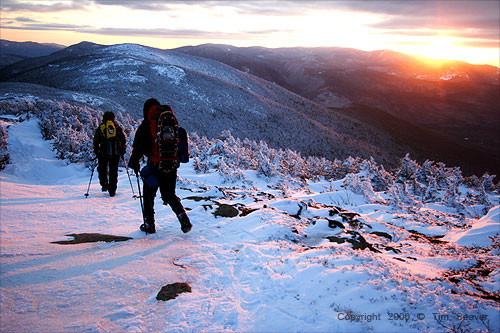
In general, the White Mountains and the Adirondacks in New York are considered to have the most difficult terrain on the east coast, and some of the most difficult terrain in the country. All variations of the New Hampshire 4,000 Footers FKT hit the most iconic parts of the White Mountains, including the Presidential Range and Franconia Ridge. The trails on the 4,000 Footers are steep and rocky, and switchbacks are few and far between. The White Mountains are notorious for volatile weather that can be deadly when it turns bad. It is not uncommon for the 4,000 footers to experience snow storms, even in the summer months.
Status: The “standard” and “self-powered” variations of this route are the #5 (tie) Ranked Northeast Region FKT. The winter variations of this route are not included in that #5 ranking. It is best practice to announce your attempt in advance, track your attempt diligently (GPS upload), and live-track your attempt if possible.
The New Hampshire 4,000 Footers has a history of Fastest Known Time Of the Year Awards:
- 2019: Arlette Laan, #1 Female (unsupported)
- 2022: Alyssa Godesky, #4 Female (supported)
Support Style: Both supported and unsupported styles on the New Hampshire 4,000 Footers have significant history. Traditionally, the “standard” route variation has been raced in a supported fashion, which involves driving between trailheads.
The “self-powered” variation of the route involves linking up all of the mountains in a thru-hiking fashion, (a continuous footpath without driving), and it has generally been raced in an unsupported fashion. Completing the 4,000 footers in this manner is known in the White Mountains community as a “White Mountains Direttissima”. Direttissima in Italian means “very direct”, which makes sense as the goal of the Direttissima is to connect all of the peaks in the most direct manner. The self-powered FKTs that were not technically unsupported were still generally completed under a self-sufficient ethic (see individual trip reports for more information). Some important details with regards to the unsupported FKT that are frequently asked and have been established by precedent:
- You may get water and use the bathroom at the various buildings throughout the Whites (AMC Huts, Mt. Washington Observatory, Pinkham Notch, etc.) as they are free and open to the public.
- You may drop your pack for out-and-backs, but as is the case for all unsupported efforts, you must start and finish with all of your gear.
- You may not stay at paid campsites or huts to sleep and may not buy supplies or accept any aid along the way.
- All other standard rules for unsupported efforts apply.
Route History:
The New Hampshire 4,000 footers list dates back to the early 1930s when the list was first created by a librarian at Dartmouth College named Nathanial Goodrich to encourage hikers to explore different areas of the White Mountains. Originally the list was comprised of 36 mountains. The list has been updated throughout the decades as measurements have become more precise and definitions of prominence requirements have been modified. In 1980, the current number of 4,000 foot peaks - 48 - was solidified. It turns out Mount Tecumseh is a few feet short of 4,000 feet, but it continues to be included on the list for historical reasons. Today, thousands of hikers every year work towards their goal of finishing the New Hampshire 48.
Speed trips for climbing all the NH 4000ers go back decades -- at least to the 1970s, when there were only 46 recognized 4000ers. In 2002, when Ted “Cave Dog Keizer” set the supported FKT, he set forth a set of rules in an attempt to standardize supported speed efforts on the 4,000 footers. That page of rules can be found here. Some of the rules have been updated over time by members of the White Mountains community, but many of them still stand, and it is an interesting historical page. If there is a discrepancy between that page and the rules listed on the FKT website, assume that the rules have been updated and that the rules on this page are the correct rules. For rules to be changed, generally the process must meet a few criteria: 1.) The new rule should make the route harder. 2). The person advocating for the change must beat the old FKT while adhering to the new “harder” rule. 3). There should be broad consensus among the community of current and previous FKT holders about the rule change. An example of this is when the timing of the men’s supported record was changed in June 2022 from “first trailhead to last summit” to “first trailhead to last trailhead” in order to maintain parity with all of the other categories of New Hampshire 4,000 Footers FKT.
The self-powered or “White Mountains Direttissima” FKT dates back to 1970 when a reverend named Henry Folsom connected all of the 4,000 footers with a continuous footpath. His hike consisted of 19 days of hiking over the course of 78 total days, in between which he would drive home. His effort is not listed on the leaderboard because the spirit of his effort was not a speed attempt. Thru-hiking the New Hampshire 4,000 footers really gained popularity around 2007, however, the number of total finishers is still small. Although the exact number is not known, it can safely be claimed that fewer than 50 people total have finished the White Mountains Direttissima.
Media Coverage:
- Bill Tidd’s 2023 supported FKT was covered on the podcast From the Backcountry
- Alyssa Godesky’s 2022 supported FKT in Trail Runner Magazine
- Will Peterson’s 2022 supported FKT in Gear Junkie
- Lyla Harrod’s 2022 unsupported FKT in Outside Magazine
- Stefanie Bishop’s 2021 supported FKT in Like the Wind Magazine
- Will Peterson’s 2020 unsupported FKT was covered on the Trail Tales Podcast
- Arlette Laan’s 2019 unsupported FKT on Gossamer Gear Blog
- Andrew Drummond’s 2016 supported (self-powered) FKT in Trail Runner Magazine
- Andrew Thompson’s 2014 supported FKT is discussed on the Kristian Ultra Podcast
Route Variations/Rules: The New Hampshire 4,000 footers is unique in that there is no set route. Any route may be taken as long as it fits the following criteria for the respective route variations. For the self-powered variation, a route must connect all 48 4,000 footers in a continuous footpath, starting and ending at established trailheads. For the standard variation, cars may be taken between trailheads, but an athlete may not ride in a vehicle up Mount Washington or use any other mechanical means to ascend the mountains (e.g. chairlifts).
All FKT attempts must strive to avoid use of private land that is not widely available to the public. Private land that is widely available to the public is defined as land that is frequently used by hikers outside of FKT attempts and does not require seeking permission from the land owner. Additionally, the gate near the Berlin Fish Hatchery to access Mount Cabot via York Pond Road is often closed at night. It has been established that one may not call ahead and ask for the gate to be left open. However, it is acceptable to leave a vehicle on the other side of the gate before it is closed, that way when the gate is closed one can switch cars at the gate and still drive down York Pond Road (this is the strategy Bill Tidd employed on his 2023 supported FKT, which was accepted by other FKT holders).
Starting in June 2022, timing for all FKT attempts on the New Hampshire 4,000 Footers begins at the first trailhead and ends at the last trailhead, not the last summit. Finally, there are winter variations for this route, which are defined as efforts that take place in their entirety between the winter solstice and spring equinox.
Sources: Appalachian Mountain Club.
History:
Speed trips for climbing all the NH 4000ers go back decades -- at least to the 1970s, when there were only 46 recognized 4000ers. This site has an excellent summary of records going back to the Fitch Brothers (George and Tom) who did all 46 recognized 4000ers in 6d15h30m, in August 1973.
"Cave Dog" Ted Keizer established a stout record for climbing all the 4000ers of 3d17h21m, August 9-12, 2002. Cave Dog's site lays out a set of rules for the trip which included no set route, allowance for resupply at any point, and that the clock would start at the first trailhead, and stop at the summit of the last peak. Also, Mt. Washington must be climbed on foot (not using the road or cog railway). These apparently reflect the accepted rules for this venture.
Beginning on July 6 at 5:00 am, and ending on July 9, 2003, at 8:51 pm atop Owl's Head mountain in the Pemigewasset Wilderness, 41 year old Vermont photographer Tim Seaver set a new record for speed climbing all 48 4000 foot peaks in New Hampshire. With the support of his wife Elisabeth and a small group of friends, as well as a network of cached water bottles placed by him along the route previously, he set a new record of 3d15h51m, beating Cave Dog's previous record by exactly 1h30m.
Mats Roing did a self-supported effort of 10d 12h 7min in 2007 and have an inspiring report here.
It took over a decade for Seaver's record to go down, but during July 7-10, 2014, Andrew Thompson did the 48 peaks in a new FKT time of 3d14h59m. Thompson was crewed by Travis Wildeboer and Jonathan Basham. An article about Thompson's adventure is here.
Brianna Tidd set a new women's FKT for the 4000ers by just 16 minutes, 4d19h40m (TH-to-TH), September 8-13, 2014. Tidd hiked the entire way with her father Bill, whose report includes a link to GPS points from their SPOT unit. The pair were supported by Brianna's mother. Brianna's own report is here.
"The Whites are a place where you feel all-powerful and overpowered at the same time. My dad and I had the incredible experience of feeling the extremes of this dichotomy while testing our own limits (or at least mine) over the course of 4 days, 19 hours, 40 minutes completing New Hampshire’s 48 4000 footers. We lost our coordination and sometimes the better part of our consciousness. We laughed a lot; I cried a little (sorry dad). It was a failure and a success." -- Brianna Tidd
Previously, Cath Goodwin had the women's best time of 4d19h56m, set Aug. 27 - Sept. 1, 2010. Her detailed report is here, where Tim Seaver also reports: Starting on August 27 at 5:14 am at the base of Carrigain, and finishing at 1:12am on Sept 1st at the base of Moosilauke, Cath Goodwin has completed the NH 48 in 4 days, 19 hours, and 56 minutes. She was supported by Tim and Val Charboneau, and harassed by me on a few hikes. Synopsis: It was hot. It was cold. It was beautiful. It was even windy at times. Occasionally, people got tired. Alright...that's my version and I am sticking with it.
Prior to Goodwin, Sue Johnston had the women's FKT for the NH 48, as reported on this thread. Sue reported as follows:
"Started at 4:01 am on Sunday morning with a south-to-north Presi Traverse, including Isolation. Finished the day with Waumbek and Cabot.
Monday, my umbrella and I did the Wildcat-Carter-Moriah Traverse in drizzly, wet conditions. Slimy rocks greatly hampered pace--boo! Finished the day with Tom-Field-Willey. Cruddytoes joined me for Field and Willey (THANKS AL!).
Tuesday was a lovely day for Carrigain, Passaconaway-Whiteface-Tris, and Hancocks.
Wednesday--another beautiful August day for Tecumseh, Osceolas, Moosilauke, and Cannon-Kinsmans.
Finally, yesterday was up Flume Slide, across Franconia Ridge, down Lincoln Slide with Neighbor Dave (bushwhacker extraordinaire who joined me for the Owls Head slog--THANKS NEIGHBOR!), then up to Garfield, Galehead, Twins, Bonds, Zealand, and Hale.
My "finish line" was the Hale Brook Trailhead. It is my personal opinion that the clock should run from "car to car." Since I am the first to establish the women's non-winter Fastest Known Time (please correct me if I'm mistaken), my preference is for the clock to stop at the trailhead of the last peak vs. the top of the peak as the men have traditionally done.
Except for Field, Willey, and Owls Head, I hiked solo. My husband Chris joined me for the first couple of miles of the Hancocks and the lower part of Cannon. He did a mighty fine job of crewing... although I don't think he knew quite what he was getting himself into. (THANKS CHRIS!)
Due to lingering, deep-seated fatigue after thru-hiking the Long Trail in 9 days beginning July 17, I'd actually decided to bail on my plan of a speedy 48. Realizing, however, that this would probably be one of my last chances to do a fast'ish time (gettin' old!), I had a change of heart: on Thursday of just last week I decided to go for it.
My goal was sub-5 days rather than attempting to better the current and previous male record holders, Tim Seaver and Ted Keizer... not that I could if I wanted to! I wanted this adventure to be more fun than toil--to say, I didn't want to suffer TOO badly--and, for the most part, was successful in that regard. (Knees started to ache a bit last night but still did the entire thing drug free--yay!) Each night I got a decent amount of sleep, and except for a night of camping at the Carrigain trailhead, I got to clean up in a shower! After all, this IS the chick's FKT." -- Sue Johnston
Arlette Laan thru-hiked the NH 4000ers completely unsupported in 11d19h (TH to TH, 11d15h TH to last summit), completed September 15, 2014, as reported below (with link to her TR). "I carried all my food and other supplies for the entire trip and everything was connected on foot," she said. Mats Roing had done a similar "thru-hike" of the 4000ers in 10d12h7m days in 2007, as reported here (Roing called this "Directissima"), but his trip was not completely unsupported. Roing did not carry his camping gear to his first campsite and spent the last night in a B&B when the weather turned bad. Ariel and Anna Feindel handily beat these times, doing the unsupported thru-hike of the NH 4000ers in 8d8h37m (TH to last summit), August 29 - September 6, 2015, as reported below. Andrew Drummond tackled the "Direttissima" in July 2016, finishing the peaks in a quick 5d23h58m. Drummond's trip cannot be considered truly "unsupported" since he cached batteries for his electronic devices and also had accompanyment at times (which could be considered "pacers"). These decisions generated a good deal of controversy and discussion, e.g., on VFTT. Since unsupported style is meant to reflect a self-sufficient ethic, we view this trip as technically "self-supported". Discussion of how we discriminate different categories of support is here.
New Hampshire winters are notoriously tough, so doing all the 4000 footers in winter is kind of a big deal. Success depends on fitness & toughness, of course, but also on having good luck with weather and conditions. For the winter records, the clock is stopped at the trailhead at the base of the last mountain (i.e., car-to-car), as opposed to at the top of the last mountain, as in the summer records. During the winter of 2003-04, Sue Johnston and Robert Williams climbed all 48 peaks in 10d22h37m. Sue's blog says "Since we were the first to do so in winter, we sort of traversed uncharted territory and played it a bit conservatively some days." The winter record was broken in 2006 by Tim Seaver, who climbed all 48 in 9d20h24m, during March 6-16, 2006. Cath Goodwin also participated in this trip, and set the women's FKT at 9d23h13m, losing a little time after she "...wiped out enroute to S Kinsman on day 8 and developed two spectacular black eyes...", and paid a visit to the ER. In January 2010, Ryan Welts set a new winter FKT. He started with Jason Ferris and Mats Roing 6:20 a.m. on Saturday 1/16/10. Roing dropped out partway through day four at the summit of Mt Garfield and Ferris skipped north and south Hancock at the end of day seven then rejoined Welts on the final day. Welts' finishing time was 7d17h7m. The trip was "mostly self supported". The trio did "a lot of prep hikes to make sure rarely touched routes were somewhat consolidated". They wore snowshoes "95% of the time", and averaged 28 +/- miles a day and 9000ft +/- of gain a day. Sue Johnston reclaimed the women's winter FKT with a trip on March 10-18, 2010. Her time was 8d4h2m. "We were actually on target to better Ryan's record until a couple of days of bone-chilling rain necessitated a switch to Plan B," said Sue. A detailed account of the trip is on her blog. There is a website dedicated to climbing the 4000 footers in one winter season.
Another NH 4000ers project that has emerged is doing all the peaks in every month of the year. This works out to 576 ascents (48 x 12)! A website dedicated to this currently (1/1/2017) lists 70 people who have finished this mamouth task. In a truly mind-boggling feat, in 2016 Sue Johnston completed the Grid in a single year! She reports hiking 3181 miles and over one million vertical feet during 205 days! An article about her quest is here.
"[I'm] just a gal who's always enjoyed playing in the woods and climbing mountains...albeit perhaps just a bit OCD?" - Sue Johnston
"Sue is the steadiest, healthiest, most durable person I know!" - Doug Mayer

Comments
Brianna Tidd and Bill Tidd left the Webster-Jackson trailhead at 9:06am. They are looking to improve on the current supported records. They are tracking via a Garmin InReach as well as GPS logs from their watches.
Hey there white mountain hiking community. My name is Josh and I am in need of some assistance. I am hoping to go unsupported on the Diretissma this summer, connecting all 4000ft peaks in NH by foot and without any resupplies. I believe Andrew Drummond (self supported) has set the bar up to this point going at 5 d 23h 58m.
I plan on documenting the journey through pictures and video (instagram) and writing a trip report at the completion. I do not have a GPS device (spot or DeLorme), but if someone was willing to loan theirs out for the week (for verification purposes) I would be very grateful.
Thanks for considering!
I am attempting an unsupported thru-hike of the NH-48, beginning this morning. My tracker link is: https://us0-share.inreach.garmin.com/billtiddnh48
I am attempting an unsupported (I think, but there seems to be some ambiguity regarding use of the huts and ditching the pack on out and backs) hike of the NH-48. I'll start tomorrow morning at about 9 AM from the Gorge Brook TH at Moosilauke. I'll be shooting for a route that matches historical attempts while trying to maximize my up-and-overs within reason. Should be fun! My tracker link is HERE.
Currently experiencing bad tendinitis making it difficult and unsafe to move fast on technical terrain. I plan to finish but an FKT is off the table.
I will be attempting a self-supported thru-hike of the 48 in July, timeline dependent on when I get a good stretch of weather. I am going to follow how Andrew Drummond structured his hike as far as being self-supported instead of unsupported (people can come join me, I will take water from huts, and I will drop my pack for out and backs). I will post a link to my tracker before I go as well as any other links to Youtube videos or online blog posts that further explain my project.
Looks like Andrew’s trip was incorrectly characterized as self supported. Since he had some company we consider it supported. Please read the Guidelines.
Hi Peter,
Thanks for the criteria update - I do however have some questions resulting from this change. First, I have read the guidelines; I had assumed that I could base my planning off of the precedent for the hike that was approved by the website and maintained for the past 4 years. Second, the current categorization does leave me fairly confused. Drummond's record is now listed as "supported" under the "self-powered" tab, separate from the "standard" tab which contains the rest of the "supported" hikes. Is there a distinction? The guidelines don't seem to mention one. Following that, if I beat Drummond's record while adhering to the same rules that he used (big if), will my time be shown as "supported" along with his time under the "self-powered" tab, or will my time not be listed because I did not beat the rest of the "supported" but not "self-powered" hikes? Any clarification would be greatly appreciated because I'd like to get out there very soon, and I want to ensure that my attempt meets the given criteria and isn't foiled due to a category error.
"Self powered" means the person did not use motor vehicles to get between trailheads. That could be hiking, or using a bicycle (which would also be "multisport"). Does that answer your question?
That makes sense. Thank you for the clarification!
Tomorrow I plan to set out on my Direttissima attempt. I am leaning towards not having people come join me in order to keep it self-supported, but I will make it clear in my trip report afterwards. Here is the link to my SPOT device which will go active tomorrow morning!
https://maps.findmespot.com/s/YB88
I plan to set out tomorrow 7/24/20 on an unsupported Direttissima attempt. I will be tracking via a Garmin inreach (keeping the link private until after my trip, but I have shared it with the FKT team). Also supplementing my track with a Garmin Forerunner and on Instagram @meaghanwmd.
Had to call off my trip halfway due to a knee injury! An incredible journey & learning experience. Hope to try again someday :)
I will be starting out tomorrow morning for an unsupported Direttissima attempt. I will have a Garmin inreach. https://share.garmin.com/EliBurakian. will try to share on social if possible.
Tomorrow I am heading out for an attempt at the supported/standard FKT (Andrew Thompson's record). I have an awesome support crew that will be helping me along the way, headed by my brother Ben. I will post my tracking link along with updates when I am able on my Instagram page @_will.peterson
Tomorrow, July 6th, 2022, I am heading out for a supported attempt on the FKT for the 48!
Tracking link is here - http://live.enabledtracking.com/nh4000/
Looking forward to a few days of fun in the mountains!
Respectfully, I don't agree with Alyssa's proposed rule about the gate on York Pond Road. There are several reasons for this, but the biggest for me is that it's fairly common knowledge that this gate hardly ever closes anyway, so the rule seems pretty unenforceable. Are people not allowed to access this trailhead at night even though the gate is likely to be open? And if people are only allowed to access this road during the day, what if they start Cabot before the cutoff but make it down at night? The Bunnell Notch Trail is the most obvious and definitely the traditional way to get up and down Cabot on speed attempts, and people have navigated the gate on this road without issue for a long time. I don't think blocking off this trail at night enhances the route in any real way.
I also disagree with the idea that exceptions are being made. Someone please correct me if I'm wrong, but to my knowledge, the people at the Fish Hatchery are happy to make sure the gate is left open for you if you ask, regardless of who you are.
As far as the use of private land, it's standard practice to hike up/down the ski slopes on both Wildcat and Tecumseh, as well as for support crews to use the Mount Washington Auto Road. I could be wrong, but I believe those are all private land or at least leased land.
I asked around a lot about the gate and definitely didn't feel like it was common knowledge that it was often left open -- at least no one wanted to tell me that, ha! If it's left open, I think that's fine, but I was under the impression if you called and requested it open they might leave it open for you, and I think that's not a precedent to set to make attempts fair/equal (what if they start to change their mind about that, etc -- who knows who is making that decision). At the end of the day I think if it's left open, then yes that's fair and use it! But if you have to request it or you come across it closed, then you have to go around to the other side. So it's up to the person if they want to check if it's open. Since there is another access point (which really isn't too much different) I don't think it's too important, but I just don't want people to feel like they need to be on the hook of asking for permission of leaving it open to be able to be on the same playing field for their route.
The auto road and ski slopes present more of a fair / equal access point (assuming no one is having their crew figure out how to drive up the auto road outside of the hours they allow to do so). Though, there is the access road at Wildcat that helps a bit, and we did wait until that was opened for the morning as well to access the base there.
The private land is mostly in regard to the Waumbek --- some folks encouraged me to use the private land access which has been shut for some time now because they think that's what Andrew Thompson used (not sure of the status of it when he did it) since it's faster. I obviously went from the public Starr King Trailhead.
Hello! I am starting an FKT attempt at ~3:30am tomorrow morning (6/11/2023). Excited to get this adventure started and thanks to all those who have attempted this before for the inspiration!
Hi Friends of the White Mountains! I wanted to check in here after a few discussions with prospective FKT attempters :) For my proposed rule on only using Public Land, I don’t want people to get hung up in the details on this. Perhaps it should read “public land and/or well defined public access points” …. i.e. if a White Mountains Trailhead is technically on private land, but it’s on the AMC maps as a designated trail head - that is of course totally fine. The intent of me asking people to not use private land / areas that require special permission is to alleviate “secret” knowledge from the route or the chance that future attempters may not be granted permission. If an access point though is clearly defined and easily found via public maps etc, then that would be no issue.
All of that said, I certainly don’t intend to be policing efforts. I encourage people to use good faith and do their homework…if you aren’t cutting corners I don’t think you have anything to worry about!
I am starting a supported FKT attempt tomorrow morning (6/20/23) at approximately 7 AM. A map of my tentative route is available at https://caltopo.com/m/UF9GE, and my tracker page is at https://share.garmin.com/billtidd. Many thanks to all those who have helped me prepare for this and those who are supporting me in this effort!
I am going to be starting a attempt to best the self powered record starting on 8/1/23 at about 5am. My live tracker is https://share.garmin.com/HXCK6.
I'll be starting an attempt at the self powdered and unsupported FKT on July 4th. I'll record a gpx track with my watch and will take pictures of my watch showing the time of day at each summit for verification.
A map of my tentative route is available at https://caltopo.com/m/T901Q
I'll be giving the unsupported Direttissima a crack in the next two weeks.
Here's my planned route: https://caltopo.com/m/ETFET5G
Here's my tracker: https://live.garmin.com/joffrey
My shoe midsole delaminated near the summit of Carter Dome (peak 4), about 165 miles and 4 days and 4 hours into my effort. I shuffled to a trailhead and ended my effort.
Such a pity, hope you will try again.
/Torben
Ill be starting an unsupported hike of the Direttessima tomorrow morning.
here is my live tracker: https://share.garmin.com/Victoriacole
I am extremely humbled by this experience. I had to pull off because my bag was too heavy and I wasnt making pace. So amazed by anyone who has completed this, especially those with an FKT. Ill come better prepared next time!
I'm planning to start a supported, self-powered White Mountains Direttissima tomorrow, Thursday 7/16! Thanks all for your inspiration.
Unfortunately I had to call it after 163 miles due to windy weather on the Bonds and being on a life time crunch... may try again at some point! Write-up is on my blog: https://serenablacklow.substack.com/p/a-first-go-at-the-white-mountains?r=5porva